


The new Kosciuszko Bridge offers multi-modal passage between boroughs, views to the Manhattan skyline, and probably impossible promises of congestion reduction.
Azi Paybarah and Nate Schweber report from New York City:
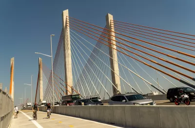
The second span of the cable-stayed Kosciuszko Bridge (arguably pronounced ko-SHCH-OO-SH-ko), which connects Brooklyn and Queens over Newtown Creek, opened to vehicles on Thursday as part of an $873 million project. The first span opened in 2017. Both spans replaced the crumbling bridge that opened in 1939 and became a despised crossing because of its choking traffic.
The new span carries traffic to Brooklyn. The previously opened span carries traffic to Queens. The bridge also includes a 20-foot wide protected lane for pedestrians and people on bikes.
New York Governor Andrew Cuomo was on hand for the grand opening of the bridge the day before the bridge opened to traffic. Governor Cuomo claimed the bridge would reduce congestion by 65 percent, though that claim is met with skepticism in the article. "The new bridge is 35 feet lower than the original. The shorter incline allows large vehicles to maintain a consistent speed, reducing congestion," according to the Paybarah and Schwerber.
The article also includes early reviews and impressions of the new bridge from the first members of the public to use the new span last week.
FULL STORY: The City’s Most Hated Bridge Gets a Nearly $1 Billion Makeover

New York City's Kosciuszko Bridge Getting Demolished
Traffic-plagued Kosciuszko will soon be replaced, and some commuters are celebrating its demise.
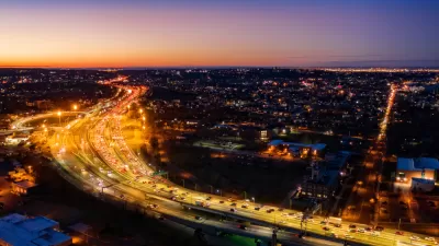
Manhattan Traffic Spreading to Other Boroughs
New travel patterns and an increased reliance on delivery services and ride-hailing are creating more congestion in New York's outer boroughs.
First New Bridge to Manhattan in Decades Proposed Just for Pedestrians and People on Bikes
Introducing the proposed Queens Ribbon Bridge, a $100 million idea to connect Manhattan to Long Island City in Queens, by way of Roosevelt Island.

Planetizen Federal Action Tracker
A weekly monitor of how Trump’s orders and actions are impacting planners and planning in America.

Congressman Proposes Bill to Rename DC Metro “Trump Train”
The Make Autorail Great Again Act would withhold federal funding to the system until the Washington Metropolitan Area Transit Authority (WMATA), rebrands as the Washington Metropolitan Authority for Greater Access (WMAGA).

DARTSpace Platform Streamlines Dallas TOD Application Process
The Dallas transit agency hopes a shorter permitting timeline will boost transit-oriented development around rail stations.

LA County Creating Action Plan to Tackle Extreme Heat
Los Angeles County is creating a Heat Action Plan to help communities stay safe during extreme heat, with steps like adding more shade, improving buildings, and supporting the neighborhoods most at risk.

Maryland Plans Quick-Build Complete Streets Projects
The state will use low-cost interventions to improve road safety in five Maryland counties.

Downtown Los Angeles Gears Up for Growth
A new report highlights Downtown L.A.’s ongoing revival through major housing projects, adaptive reuse, hospitality growth, and preparations for global events in the years ahead.
Urban Design for Planners 1: Software Tools
This six-course series explores essential urban design concepts using open source software and equips planners with the tools they need to participate fully in the urban design process.
Planning for Universal Design
Learn the tools for implementing Universal Design in planning regulations.
City of Charlotte
Municipality of Princeton
Roanoke Valley-Alleghany Regional Commission
City of Camden Redevelopment Agency
City of Astoria
Transportation Research & Education Center (TREC) at Portland State University
US High Speed Rail Association
City of Camden Redevelopment Agency
Municipality of Princeton (NJ)