


Study participants were more likely to support sustainable transportation projects when shown AI images of what the completed real-life infrastructure would look like, suggesting generative AI could be a useful tool for planners.
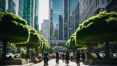
Researchers in a new study published in Nature showed people AI images of what United States cities would look like with fewer cars and more space for pedestrians, cyclists, and public transit — and people liked what they saw. In fact, they were more likely to support government spending to implement those sustainable transportation policies than people to whom the project and concepts were just described. Petapixel senior news editor Matt Growvcoot explored the study’s results in a recent article.
“The MIT Sloan School of Management presented 3,100 participants with a hypothetical $500 million bill that would replace half of all car lanes in the United States with bus lanes, bike lanes, and wider sidewalks. The subjects were shown a photograph taken from Google Street View showing a cityscape dominated by cars and then three AI alternatives showing how the bill could affect urban environments,” he writes. “The participants who saw the AI illustrations of the city designed for pedestrians rather than cars were more likely to say they would support the fictional bill. Other participants who were simply shown slides with words such as 'greener' and 'bikeable' or rudimentary cartoons of public transport and foliages were less likely to show support for the bill.”
In car-centric America, people have very strong opinions and reactions when planners and policymakers start talking about “taking away” cars, or space from cars. Could AI-generated images be the key to building public support and political will around sustainable transportation projects? This study certainly suggests so. Regardless, it seems like one ethical use of AI-generated images and a potentially valuable AI tool to add to planners’ toolkits.
FULL STORY: People Support Car Bans When Shown AI Images of What Cities Would Look Like


In Urban Planning, AI Prompting Could be the New Design Thinking
Creativity has long been key to great urban design. What if we see AI as our new creative partner?

Four Reasons Urban Planners Can’t Ignore AI
It’s no longer a question of whether AI will shape planning, but how. That how is up to us.
USDOT Could Pull Green Infrastructure Grants
A new department memo requires a review of projects with the goal of removing bike, pedestrian, and electric vehicle infrastructure.

Planetizen Federal Action Tracker
A weekly monitor of how Trump’s orders and actions are impacting planners and planning in America.

Restaurant Patios Were a Pandemic Win — Why Were They so Hard to Keep?
Social distancing requirements and changes in travel patterns prompted cities to pilot new uses for street and sidewalk space. Then it got complicated.

Map: Where Senate Republicans Want to Sell Your Public Lands
For public land advocates, the Senate Republicans’ proposal to sell millions of acres of public land in the West is “the biggest fight of their careers.”

Maui's Vacation Rental Debate Turns Ugly
Verbal attacks, misinformation campaigns and fistfights plague a high-stakes debate to convert thousands of vacation rentals into long-term housing.

San Francisco Suspends Traffic Calming Amidst Record Deaths
Citing “a challenging fiscal landscape,” the city will cease the program on the heels of 42 traffic deaths, including 24 pedestrians.

California Homeless Arrests, Citations Spike After Ruling
An investigation reveals that anti-homeless actions increased up to 500% after Grants Pass v. Johnson — even in cities claiming no policy change.
Urban Design for Planners 1: Software Tools
This six-course series explores essential urban design concepts using open source software and equips planners with the tools they need to participate fully in the urban design process.
Planning for Universal Design
Learn the tools for implementing Universal Design in planning regulations.
Heyer Gruel & Associates PA
JM Goldson LLC
Custer County Colorado
City of Camden Redevelopment Agency
City of Astoria
Transportation Research & Education Center (TREC) at Portland State University
Camden Redevelopment Agency
City of Claremont
Municipality of Princeton (NJ)