


With the ability to predict trends, engage citizens, enhance resource allocation, and guide decision-making, artificial intelligence has the potential to serve as planners’ very own multi-tool.
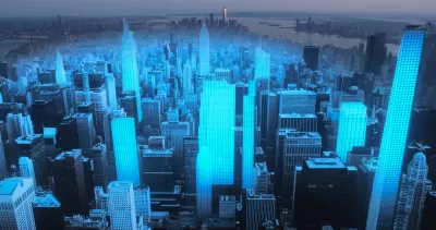
“The convergence of artificial intelligence (AI) and urban planning holds significant promise for creating more intelligent, efficient, and sustainable cities,” Camilla Ghisleni. In an article for Arch Daily, she outlines four applications of urban planning, spurred by “a surge in development of applications, softerware, and other technological systems” tailored to support city design.
1. Urban design and morphology
Ghisleni cites multiple projects and studies around the world that are using AI to analyze and create plans in a fraction of the time it would take human urban planners and with better results, including grid-based planning, rapid urban prototyping, and digital twin technology.
2. Resilience and climate adaptation
AI can also be used to enhance resilience against extreme weather events and climate change, Ghisleni reports, pointing to Google’s AI-powered tree-cover assessment tool and IBM’s AI tool that calculates the amount of carbon trees in specific areas can store, which can help when choosing species for carbon sequestration.
3. Infrastructure planning
Ghisleni highlights a software called MAIIA (Automated Mapping of Informal Settlements with Artificial Intelligence) that was created by Columbia’s National Planning Department and made available as part of a catalog of open-source tools for urban planning, with the goal of facilitating “automated detection and mapping of informal settlements in various locations, providing efficient and accessible solutions to housing challenges.”
4. Community engagement
Finally, Ghisleni covers applications including virtual reality (VR) or augmented reality (AR) to encourage a more participatory planning process, as well as real-time monitoring and analysis of user-generated data for things like traffic management and route safety alerts for women and pedestrians.
FULL STORY: Artificial Intelligence and Urban Planning: Technology as a Tool for City Design

Augmented Reality and Public Art: A New Era Begins Today
People in six global cities will have a chance to sample an ambitious new augmented reality program launched by Apple today.

Making a Place for Virtual Reality in Planning
As virtual reality technology becomes more accessible, it's time to start considering how immersive virtual experiences could help inform visioning process and design decision-making.

Cal Fire Chatbot Fails to Answer Basic Questions
An AI chatbot designed to provide information about wildfires can’t answer questions about evacuation orders, among other problems.

Maui's Vacation Rental Debate Turns Ugly
Verbal attacks, misinformation campaigns and fistfights plague a high-stakes debate to convert thousands of vacation rentals into long-term housing.

Planetizen Federal Action Tracker
A weekly monitor of how Trump’s orders and actions are impacting planners and planning in America.

In Urban Planning, AI Prompting Could be the New Design Thinking
Creativity has long been key to great urban design. What if we see AI as our new creative partner?

King County Supportive Housing Program Offers Hope for Unhoused Residents
The county is taking a ‘Housing First’ approach that prioritizes getting people into housing, then offering wraparound supportive services.

Researchers Use AI to Get Clearer Picture of US Housing
Analysts are using artificial intelligence to supercharge their research by allowing them to comb through data faster. Though these AI tools can be error prone, they save time and housing researchers are optimistic about the future.

Making Shared Micromobility More Inclusive
Cities and shared mobility system operators can do more to include people with disabilities in planning and operations, per a new report.
Urban Design for Planners 1: Software Tools
This six-course series explores essential urban design concepts using open source software and equips planners with the tools they need to participate fully in the urban design process.
Planning for Universal Design
Learn the tools for implementing Universal Design in planning regulations.
planning NEXT
Appalachian Highlands Housing Partners
Mpact (founded as Rail~Volution)
City of Camden Redevelopment Agency
City of Astoria
City of Portland
City of Laramie