


Access to transportation is a major hurdle for many community college students, but local transit systems often fail to serve them.
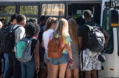
Writing for WDET, Eli Newman reports on a new study from the Civic Mapping Initiative that reveals that 44 percent of Michigan’s community colleges are not within 4.5 miles of a bus stop or transit station. According to Bill Moses, managing director for the Kresge Foundation’s Education Program, “We found that for many low-income students, transit is one of the biggest barriers to actually going to college. It’s literally getting there.”
Newman notes that “The Civic Mapping Initiatives claims by extending bus lines or making other route adjustments, an additional 25% of community colleges could become accessible by public transit.”
Abigail Seldin, co-founder of the Civic Mapping Initiative, points out that distance to transit is just a starting point for determining true accessibility. “Access requires affordable fares, routes that work, stops where you want to go,” Seldin explains.
Seldin urges stronger collaboration between colleges and local and regional transit agencies. “Right now there’s tremendous recovery dollars around. There’s a focus on workforce attainment, and connectivity and public transit investment. If we want students to be able to get to school to get workforce training, they have to be able to actually set foot on the campus in many cases, and there’s not a better time for folks to come together to really work on this.”
FULL STORY: Survey: Most Michigan community colleges out of reach of public transit

Opinion: Make Buses More Like Sidewalks
Sidewalks are an intuitive, low-cost, and easily accessible mobility tool. Can local buses function in the same way?

Preparing Transportation Systems for the ‘Silver Tsunami’
More Americans than ever will age beyond their safe ability to drive. How will they meet their mobility needs in a car-centric society?
Philadelphia Councilmember Proposes Transit Access Fund
The plan would allocate 0.5 percent of the general fund toward mobility subsidies for low-income households.

Planetizen Federal Action Tracker
A weekly monitor of how Trump’s orders and actions are impacting planners and planning in America.

Map: Where Senate Republicans Want to Sell Your Public Lands
For public land advocates, the Senate Republicans’ proposal to sell millions of acres of public land in the West is “the biggest fight of their careers.”

Restaurant Patios Were a Pandemic Win — Why Were They so Hard to Keep?
Social distancing requirements and changes in travel patterns prompted cities to pilot new uses for street and sidewalk space. Then it got complicated.

Platform Pilsner: Vancouver Transit Agency Releases... a Beer?
TransLink will receive a portion of every sale of the four-pack.

Toronto Weighs Cheaper Transit, Parking Hikes for Major Events
Special event rates would take effect during large festivals, sports games and concerts to ‘discourage driving, manage congestion and free up space for transit.”

Berlin to Consider Car-Free Zone Larger Than Manhattan
The area bound by the 22-mile Ringbahn would still allow 12 uses of a private automobile per year per person, and several other exemptions.
Urban Design for Planners 1: Software Tools
This six-course series explores essential urban design concepts using open source software and equips planners with the tools they need to participate fully in the urban design process.
Planning for Universal Design
Learn the tools for implementing Universal Design in planning regulations.
Heyer Gruel & Associates PA
JM Goldson LLC
Custer County Colorado
City of Camden Redevelopment Agency
City of Astoria
Transportation Research & Education Center (TREC) at Portland State University
Camden Redevelopment Agency
City of Claremont
Municipality of Princeton (NJ)