


While some cities are reverting back to pre-pandemic street configurations, others are taking advantage of the momentum for bike and pedestrian infrastructure to make pandemic-era projects permanent.
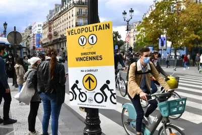
Writing in Momentum Magazine, Ron Johnson highlights three cities where pandemic-era bike infrastructure projects have become permanent.
In Toronto, Yonge Street, a busy north-south corridor, received separated bike lanes. “After 18 months of installation, the data demonstrates increases (ranging between 57 percent and 250 percent) in cycling trips and increases in pedestrian trips (ranging between 59 percent and 145 percent) on the corridor, as well as support for local business including an increase from 10 CaféTO patios in 2020 to 21 patios on the corridor in 2022.” City staff is recommending making the lanes permanent and did so for two other pandemic bike projects in the city.
In San Francisco, thanks to consistent lobbying from bike activists, Golden Gate Park’s John F. Kennedy Drive has had intermittent closures for decades. San Francisco Bicycle Coalition executive director Janelle Wong says “the emergency order shutting it down, I think for the first time allowed people to see what seven days a week, 24 hours a day of closing that street looks like and what it feels like,” making it easier to gain support for permanently implementing the change.
Across the Atlantic, Paris has been pouring massive effort into building bike infrastructure and creating more multimodal and car-free streets. The transformation of the city’s famous Rue de Rivoli into a bike and pedestrian road during the pandemic signaled a turning point for the French capital. “In 2021, one lane of traffic for transit, emergency vehicles and the like was added back and the new configuration is now permanent.”
FULL STORY: Three cities making pandemic-inspired bike expansion permanent


Paris Voters Approve More Car-Free Streets
Paris Mayor Anne Hidalgo says the city will develop a plan to close 500 streets to car traffic and add new bike and pedestrian infrastructure after a referendum on the proposal passed with 66 percent of the vote.

Battle Over San Francisco's Pedestrianized 'Great Highway'
Although the project has been hugely successful with local residents, the mayor and some county supervisors wanted to revert the road to vehicle use.
Milwaukee Launches Vision Zero Plan
Seven years after the city signed its Complete Streets Policy, the city is doubling down on its efforts to eliminate traffic deaths.

Planetizen Federal Action Tracker
A weekly monitor of how Trump’s orders and actions are impacting planners and planning in America.

Chicago’s Ghost Rails
Just beneath the surface of the modern city lie the remnants of its expansive early 20th-century streetcar system.

San Antonio and Austin are Fusing Into one Massive Megaregion
The region spanning the two central Texas cities is growing fast, posing challenges for local infrastructure and water supplies.

Since Zion's Shuttles Went Electric “The Smog is Gone”
Visitors to Zion National Park can enjoy the canyon via the nation’s first fully electric park shuttle system.

Trump Distributing DOT Safety Funds at 1/10 Rate of Biden
Funds for Safe Streets and other transportation safety and equity programs are being held up by administrative reviews and conflicts with the Trump administration’s priorities.

German Cities Subsidize Taxis for Women Amid Wave of Violence
Free or low-cost taxi rides can help women navigate cities more safely, but critics say the programs don't address the root causes of violence against women.
Urban Design for Planners 1: Software Tools
This six-course series explores essential urban design concepts using open source software and equips planners with the tools they need to participate fully in the urban design process.
Planning for Universal Design
Learn the tools for implementing Universal Design in planning regulations.
planning NEXT
Appalachian Highlands Housing Partners
Mpact (founded as Rail~Volution)
City of Camden Redevelopment Agency
City of Astoria
City of Portland
City of Laramie