


A new transit station area plan is reaching the finishing line for the Huntington Metro station, serving the WMATA’s Yellow Line in Northern Virginia.
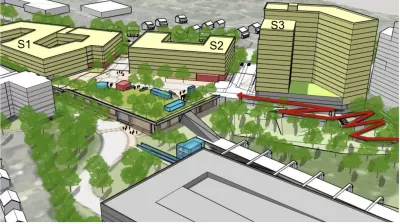
The area surrounding the Huntington Metro station in Fairfax County, Virginia, could soon have a new transit station area plan, prioritizing new transit oriented development that allows for mixed-use development, inclusionary zoning, and additional building heights.
Matt Blitz reports on the approval of the plan amendment by the Fairfax County Planning Commission on November 16. Blitz summarizes the plan as follows:
The plan calls for a mixed-use development on the site including 382,00 square feet of office, retail, and community-use space, a civic plaza, more urban park space, a network of bike and pedestrian paths, a possible hotel, and 15,000 residential units with a minimum of 15% of those being affordable.
Some of the political compromises reached during the plan’s development include lower building heights near homes on Biscayne Drive—85 feet instead of the original 200 feet.
The Fairfax County Board of Supervisors is expected to consider the plan amendment on December 6.
FULL STORY: Huntington Metro area development plan passes planning commission with big height reduction

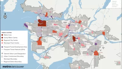
Vancouver Approves New Metro 2050 Regional Plan
The region around Vancouver in British Columbia has a new 30-year regional plan.

New Plans for Transit Oriented Development in South Central L.A.
Los Angeles County recently adopted the Florence-Firestone Transit Oriented District Specific Plan.
Feds to Award $13 Million for Transit Oriented Development Planning
A newly bolstered competitive grant program administered by the Federal Transit Administration has announced a new round of funding.

Planetizen Federal Action Tracker
A weekly monitor of how Trump’s orders and actions are impacting planners and planning in America.

Map: Where Senate Republicans Want to Sell Your Public Lands
For public land advocates, the Senate Republicans’ proposal to sell millions of acres of public land in the West is “the biggest fight of their careers.”

Restaurant Patios Were a Pandemic Win — Why Were They so Hard to Keep?
Social distancing requirements and changes in travel patterns prompted cities to pilot new uses for street and sidewalk space. Then it got complicated.

Platform Pilsner: Vancouver Transit Agency Releases... a Beer?
TransLink will receive a portion of every sale of the four-pack.

Toronto Weighs Cheaper Transit, Parking Hikes for Major Events
Special event rates would take effect during large festivals, sports games and concerts to ‘discourage driving, manage congestion and free up space for transit.”

Berlin to Consider Car-Free Zone Larger Than Manhattan
The area bound by the 22-mile Ringbahn would still allow 12 uses of a private automobile per year per person, and several other exemptions.
Urban Design for Planners 1: Software Tools
This six-course series explores essential urban design concepts using open source software and equips planners with the tools they need to participate fully in the urban design process.
Planning for Universal Design
Learn the tools for implementing Universal Design in planning regulations.
Heyer Gruel & Associates PA
JM Goldson LLC
Custer County Colorado
City of Camden Redevelopment Agency
City of Astoria
Transportation Research & Education Center (TREC) at Portland State University
Camden Redevelopment Agency
City of Claremont
Municipality of Princeton (NJ)