


The nation's growth slowed from 2010 and 2020, according to 2020 Census data, and demographers are still trying to figure out what population trends mean for the future of country's major metropolitan areas.

William H. Frey provides insights into the growth, diversity, segregation, and aging trends in the nation’s largest metropolitan areas, as reported by the 2020 Census.
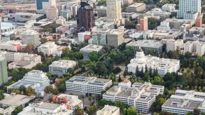
As noted by Frey, the nation’s largest metropolitan areas—with 1 million residents and more—are home to six in ten Americans, and that total is only increasing as major metro areas grew faster than smaller metro areas from 2010 to 2020.
“Moreover, the increased racial and ethnic diversity that characterized the nation is especially concentrated in major metro areas and, in particular, among their youth populations,” writes Frey.
A few other key findings from the article (which synthesizes information presented in a longer report published by Brookings Mountain West), with more detail provided in the source article below:
- Major metro areas grew more slowly since 2010 than in several previous decades.
- The fastest growing metro areas are in the Sun Belt
- Cities grew faster and suburbs slower when compared to the previous decade of the 2000s.
- All major metro areas became more racially and ethnically diverse
- Neighborhood segregation varied by metro area
- The youth population declined and became more diverse
“This analysis of the 2020 census makes plain that the 2010-2020 period represents a transitional decade for the nation’s major metro areas,” according to Frey. That transition “does not lead to a straightforward forecast about [metro areas’] future prospects.”
FULL STORY: Growth, diversity, segregation, and aging in America’s largest metropolitan areas: A 2020 census portrait

California Halts Three Years of Population Loss
The Golden State grew by 67,000 people, or 0.17%, last year, to just over 39.1 million on Jan. 1, 2024, according to a demographic report released April 30 by the California Department of Finance.

Different Approaches to Fast Growth in Idaho's Treasure Valley
Three cities on the periphery of the fast-growing Treasure Valley showcase different approaches to a sudden influx of newcomers.

Census: Big Cities Lost Population During the Pandemic
For the first time in at least three decades, major metropolitan areas in the U.S. showed negative population growth during the peak of the COVID-19 pandemic.

Planetizen Federal Action Tracker
A weekly monitor of how Trump’s orders and actions are impacting planners and planning in America.

Map: Where Senate Republicans Want to Sell Your Public Lands
For public land advocates, the Senate Republicans’ proposal to sell millions of acres of public land in the West is “the biggest fight of their careers.”

Restaurant Patios Were a Pandemic Win — Why Were They so Hard to Keep?
Social distancing requirements and changes in travel patterns prompted cities to pilot new uses for street and sidewalk space. Then it got complicated.

Albuquerque Route 66 Motels Become Affordable Housing
A $4 million city fund is incentivizing developers to breathe new life into derelict midcentury motels.

DC Area County Eliminates Bus Fares
Montgomery County joins a growing trend of making transit free.

Platform Pilsner: Vancouver Transit Agency Releases... a Beer?
TransLink will receive a portion of every sale of the four-pack.
Urban Design for Planners 1: Software Tools
This six-course series explores essential urban design concepts using open source software and equips planners with the tools they need to participate fully in the urban design process.
Planning for Universal Design
Learn the tools for implementing Universal Design in planning regulations.
Heyer Gruel & Associates PA
JM Goldson LLC
Custer County Colorado
City of Camden Redevelopment Agency
City of Astoria
Transportation Research & Education Center (TREC) at Portland State University
Camden Redevelopment Agency
City of Claremont
Municipality of Princeton (NJ)