


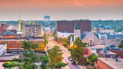
For the first time in at least three decades, major metropolitan areas in the U.S. showed negative population growth during the peak of the COVID-19 pandemic.

Data from the U.S. Census Bureau shows a strong trend toward outmigration from big cities between July 2020 and July 2021, when the pandemic was at its peak. According to a piece by William H. Frey, “These shifts occurred during a year in which the nation registered its lowest population growth (0.1%) in at least 120 years, due to sharply reduced immigration from abroad and much lower levels of natural increase (the excess of births over deaths).”
The pandemic accelerated existing trends, Frey writes, pointing to more restrictive immigration laws and a decline in childbirths for many groups as factors for lower population growth nationwide. “The onset of the pandemic-accelerated growth slowdown in major metro areas led to an absolute population loss in 2020-21 among those areas combined. This is the first time the nation’s major metro areas registered an annual negative growth rate since at least 1990.”
The article expresses optimism that pandemic-era trends will reverse and population growth will return to a healthier growth rate. But it remains to be seen how the change in commuting patterns and the amenities people prioritize will impact the growth of large cities, and whether the recent popularity of small towns and suburbs with younger households will lead to a shift in the suburban form and more sustainable suburban planning.
FULL STORY: New census data shows a huge spike in movement out of big metro areas during the pandemic


Pandemic-Era Big City Population Loss More Dramatic Than We Thought
A new analysis indicates that many big cities saw their biggest population declines in at least a decade, with suburbs also showing a slowdown in growth.

Renters Now Outnumber Homeowners in Over 200 US Suburbs
High housing costs in city centers and the new-found flexibility offered by remote work are pushing more renters to suburban areas.
Small Towns Grow Faster Than Cities for First Time in Decades
Cities of 4 million or more people lost 600,000 residents to domestic migration.

Maui's Vacation Rental Debate Turns Ugly
Verbal attacks, misinformation campaigns and fistfights plague a high-stakes debate to convert thousands of vacation rentals into long-term housing.

Planetizen Federal Action Tracker
A weekly monitor of how Trump’s orders and actions are impacting planners and planning in America.

San Francisco Suspends Traffic Calming Amidst Record Deaths
Citing “a challenging fiscal landscape,” the city will cease the program on the heels of 42 traffic deaths, including 24 pedestrians.

Defunct Pittsburgh Power Plant to Become Residential Tower
A decommissioned steam heat plant will be redeveloped into almost 100 affordable housing units.

Trump Prompts Restructuring of Transportation Research Board in “Unprecedented Overreach”
The TRB has eliminated more than half of its committees including those focused on climate, equity, and cities.

Amtrak Rolls Out New Orleans to Alabama “Mardi Gras” Train
The new service will operate morning and evening departures between Mobile and New Orleans.
Urban Design for Planners 1: Software Tools
This six-course series explores essential urban design concepts using open source software and equips planners with the tools they need to participate fully in the urban design process.
Planning for Universal Design
Learn the tools for implementing Universal Design in planning regulations.
Heyer Gruel & Associates PA
JM Goldson LLC
Custer County Colorado
City of Camden Redevelopment Agency
City of Astoria
Transportation Research & Education Center (TREC) at Portland State University
Jefferson Parish Government
Camden Redevelopment Agency
City of Claremont