


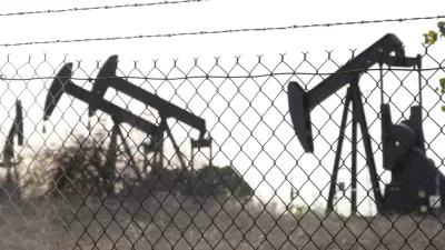
Research shows neighborhoods historically redlined by the federal government have twice as many oil and gas extraction projects as “desirable” neighborhoods.

A first-of-its-kind analysis from a research team from the University of California, Berkeley, the University of California, San Francisco, and Columbia University highlights the correlation between historical redlining and oil and gas wells in neighborhoods. As Julia Kane writes, “[The research team] compared data on the location of plugged and active oil and gas wells to data from maps generated by the Home Owners Loan Corporation, the federal lending program created to prevent home foreclosures during the Great Depression.”
Looking at data for 33 cities where oil and gas wells are drilled and operated in urban neighborhoods across 13 states, researchers discovered the striking correlation between neighborhoods that were redlined and neighborhoods that have a high density of oil and gas wells.
While the study did not establish a causal link between redlining and drilling, Kane notes, “It’s not news that redlined communities tend to experience worse health outcomes. There are also links between neighborhoods that have undergone disinvestment and neighborhoods where there are higher rates of gun violence and less green space.”
This can directly affect the health of communities living near extraction sites. “Numerous studies have found that living near oil and gas wells increases a person’s risk of cardiovascular disease, impaired lung function, anxiety, depression, preterm birth, and impaired fetal growth — serious concerns for the estimated 17 million people in the U.S. who live within a mile of at least one active well.”
FULL STORY: Historically redlined neighborhoods have twice the number of oil and gas wells

Los Angeles To Phase Out Oil Drilling
The city has banned new wells and will end all extraction within two decades.
Your Not-So-Friendly Neighborhood Oil Well
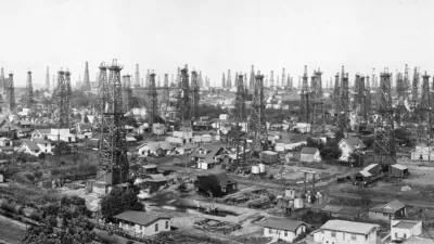
Much of California's oil and gas extraction takes place in residential neighborhoods, posing significant health risks to entire communities.
Pollution Does Discriminate in Orlando’s Parramore Neighborhood
Poor air quality has decimated the health of residents in this predominantly black community ringed by highways.

Planetizen Federal Action Tracker
A weekly monitor of how Trump’s orders and actions are impacting planners and planning in America.

Restaurant Patios Were a Pandemic Win — Why Were They so Hard to Keep?
Social distancing requirements and changes in travel patterns prompted cities to pilot new uses for street and sidewalk space. Then it got complicated.

Map: Where Senate Republicans Want to Sell Your Public Lands
For public land advocates, the Senate Republicans’ proposal to sell millions of acres of public land in the West is “the biggest fight of their careers.”

Maui's Vacation Rental Debate Turns Ugly
Verbal attacks, misinformation campaigns and fistfights plague a high-stakes debate to convert thousands of vacation rentals into long-term housing.

San Francisco Suspends Traffic Calming Amidst Record Deaths
Citing “a challenging fiscal landscape,” the city will cease the program on the heels of 42 traffic deaths, including 24 pedestrians.

California Homeless Arrests, Citations Spike After Ruling
An investigation reveals that anti-homeless actions increased up to 500% after Grants Pass v. Johnson — even in cities claiming no policy change.
Urban Design for Planners 1: Software Tools
This six-course series explores essential urban design concepts using open source software and equips planners with the tools they need to participate fully in the urban design process.
Planning for Universal Design
Learn the tools for implementing Universal Design in planning regulations.
Heyer Gruel & Associates PA
JM Goldson LLC
Custer County Colorado
City of Camden Redevelopment Agency
City of Astoria
Transportation Research & Education Center (TREC) at Portland State University
Camden Redevelopment Agency
City of Claremont
Municipality of Princeton (NJ)