


In a draft plan, planners in Arlington County, Virginia call for improved pedestrian infrastructure, higher-density housing, and more public parks.
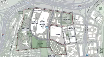
Arlington County has laid out their vision for the redevelopment of Pentagon City, which, as Jo DeVoe writes, "will include a significant amount of redevelopment and infill development, with an emphasis on residential buildings" as well as more green space and multimodal transportation infrastructure.
"[T]he draft plan divides potential redevelopment opportunities into five phases, ranging between two and five years," and "outlines the creation of at least five new acres of new parks and plazas across Pentagon City, as well as an expansion of the popular — perhaps too popular — Virginia Highlands Park by at least one acre." It also proposes "The Green Ribbon," which the draft plan calls "a new signature network of biophilic walking paths connecting public spaces, destinations, and transit throughout Pentagon City and greater 22202."
One controversial aspect of the plan is the inclusion of the RiverHouse complex, one of the largest housing complexes in the D.C. area with "significant development potential." Some residents "expressed disapproval for the impact they believed it would have on property values," while others support the conversion of surface parking near transit to housing.
On the transportation side, the plan proposes "adding a network of protected bike lanes, removing traffic lanes, improving bus facilities and beefing up micro-mobility connections to the surrounding neighborhoods."
FULL STORY: Planners Envision Greener, More Urban and Less Car-Centric Pentagon City

Report Links Housing Growth and Climate Resilience
Data from three U.S. metro areas show a failure to address land use and sprawl as a key factor driving climate change.
High Housing Costs Driving Down Transit Ridership in LA
When neighborhoods gentrify and displace lower-income residents, transit ridership suffers, new research shows.

Opinion: California’s SB 79 Would Improve Housing Affordability and Transit Access
A proposed bill would legalize transit-oriented development statewide.

Planetizen Federal Action Tracker
A weekly monitor of how Trump’s orders and actions are impacting planners and planning in America.

Maui's Vacation Rental Debate Turns Ugly
Verbal attacks, misinformation campaigns and fistfights plague a high-stakes debate to convert thousands of vacation rentals into long-term housing.

San Francisco Suspends Traffic Calming Amidst Record Deaths
Citing “a challenging fiscal landscape,” the city will cease the program on the heels of 42 traffic deaths, including 24 pedestrians.

Amtrak Rolls Out New Orleans to Alabama “Mardi Gras” Train
The new service will operate morning and evening departures between Mobile and New Orleans.

The Subversive Car-Free Guide to Trump's Great American Road Trip
Car-free ways to access Chicagoland’s best tourist attractions.

San Antonio and Austin are Fusing Into one Massive Megaregion
The region spanning the two central Texas cities is growing fast, posing challenges for local infrastructure and water supplies.
Urban Design for Planners 1: Software Tools
This six-course series explores essential urban design concepts using open source software and equips planners with the tools they need to participate fully in the urban design process.
Planning for Universal Design
Learn the tools for implementing Universal Design in planning regulations.
Heyer Gruel & Associates PA
JM Goldson LLC
Custer County Colorado
City of Camden Redevelopment Agency
City of Astoria
Transportation Research & Education Center (TREC) at Portland State University
Jefferson Parish Government
Camden Redevelopment Agency
City of Claremont