


With 65.4% of the nation's adult population at least partially vaccinated, daily new COVID cases have dropped to the lowest level since late March 2020. However, cases are increasing in some states, none more than Missouri.

"Hot spots of COVID-19 cases continue to spread across northern and southwest Missouri, sparking concerns that the virus — especially a more dangerous variant — will reach more vulnerable populations in the St. Louis and Kansas City areas," writes Michele Munz, a health reporter for the St. Louis Post-Dispatch on June 17.
Average daily cases across the state have increased to almost 600 from around 400 a day at the beginning of June, driven mainly by big upticks in outstate Missouri. With that growth, Missouri ranks third among all states for the most cases per 100,000 residents in the last seven days, according to The New York Times nationwide tracker.
Just three days later, the New York Times Missouri tracker shows the 7-day average as 648 cases on June 20. The state now ranks first, with 11 cases per 100,000 residents in the last seven days. The national case incidence rate is 3 cases per 100k, the lowest this correspondent can recall for the U.S.
Blame the variant
"Nathan Koffarnus, assistant chief of disease control with the Missouri Department of Health and Senior Services, blamed the upticks on the increasing presence of the Delta variant — which emerged in India and is shown to be more transmissible and cause more serious illness — along with low vaccination rates," adds Munz.
"In an interview with CNN on Friday, Dr. Rochelle Walensky, director of the US Centers for Disease Control and Prevention (CDC), said that the Delta variant's increased transmissibility could allow it overtake the Alpha variant [formerly referred to as B.1.1.7], first identified in the United Kingdom, in the US in the coming months," reported CNN on June 19.
"On Wednesday, the Missouri Department of Health and Senior Services issued a news release saying that the state 'is experiencing a rise in individuals contracting the Delta variant' and that it 'has become prevalent' throughout Missouri," reported Munz in a separate piece on June 17 focused on how the variant is affecting southwest Missouri.
Administrators at the two largest hospitals serving the state’s southwestern region —Mercy and CoxHealth — are exasperated with coronavirus patient loads increasing at an exponential pace that they have not previously seen in this pandemic.
Munz notes the low COVID-19 vaccination rates in the region's counties, the new demographics of COVID patients, and illustrates the increased transmissibility of the Delta variant.
Erik Frederick, chief administrative officer at Mercy Hospital Springfield, said that doctors are seeing more young, healthy adults and pregnant woman in the hospital with COVID.
At the beginning of the pandemic, every person infected with the coronavirus would infect about two people, explained Kendra Findley, administrator of community health and epidemiology with Greene County. That number rises to about four with the Alpha variant. “With Delta, that estimation can be anywhere from five to eight. That is staggering.”
Among the state's 115 counties, Greene ranks #11 highest with 36.4% of the population being at least partially vaccinated, according to Covid Act Now. The state average is 44.1%, #44. The national average for this vaccination metric is 53.3%, according to the CDC.
Other states to watch
The New York Times coronavirus database shows Wyoming and Utah as having the nation's next highest case incidence rates with 9 cases per 100,000 residents. The total population "fully vaccinated" levels are 33% and 36%, respectively, well below the national average of 45%. However, because the incidence is <10 per 100k, they don' appear in orange, or "high risk" as Missouri does on the Covid Act Now map.
Two other states colored orange on the map are Oklahoma and Arkansas for a high score on another metric: the infection rate, a measure of how fast the virus is spreading.
Related in Planetizen:
-
Pandemic Geography: What's Going on in Michigan? April 4, 2021
-
Pandemic Geography: What's Wrong in Rhode Island? December 13, 2020
Hat tip to Loren Spiekerman.
FULL STORY: Coronavirus hot spots spread across Missouri, driven by variant


State Hospitalization Record Breaks as Omicron Surges
Infections from the Omicron variant, which early studies suggest cause less severe illness than the Delta variant, may be contributing to a record number of hospitalizations in Ohio, the highest since the start of the pandemic.
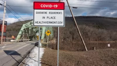
Revisiting Vermont: A COVID Update
PBS NewsHour investigates the surging coronavirus cases and hospitalizations in Vermont which, along with Rhode Island, has 75% of its total population fully vaccinated, the nation's highest, as the U.S. appears to enter a winter surge.

Delta Variant's High Transmissibility Prompts CDC to Issue Masking Correction
The Centers for Disease Control and Prevention, acting on new data that it had yet to publish, changed its masking guidance on July 27 to reflect the prevalence of the virus in specific counties rather than basing it on a person's vaccination status.

Planetizen Federal Action Tracker
A weekly monitor of how Trump’s orders and actions are impacting planners and planning in America.

Map: Where Senate Republicans Want to Sell Your Public Lands
For public land advocates, the Senate Republicans’ proposal to sell millions of acres of public land in the West is “the biggest fight of their careers.”

Restaurant Patios Were a Pandemic Win — Why Were They so Hard to Keep?
Social distancing requirements and changes in travel patterns prompted cities to pilot new uses for street and sidewalk space. Then it got complicated.

Platform Pilsner: Vancouver Transit Agency Releases... a Beer?
TransLink will receive a portion of every sale of the four-pack.

Toronto Weighs Cheaper Transit, Parking Hikes for Major Events
Special event rates would take effect during large festivals, sports games and concerts to ‘discourage driving, manage congestion and free up space for transit.”

Berlin to Consider Car-Free Zone Larger Than Manhattan
The area bound by the 22-mile Ringbahn would still allow 12 uses of a private automobile per year per person, and several other exemptions.
Urban Design for Planners 1: Software Tools
This six-course series explores essential urban design concepts using open source software and equips planners with the tools they need to participate fully in the urban design process.
Planning for Universal Design
Learn the tools for implementing Universal Design in planning regulations.
Heyer Gruel & Associates PA
JM Goldson LLC
Custer County Colorado
City of Camden Redevelopment Agency
City of Astoria
Transportation Research & Education Center (TREC) at Portland State University
Camden Redevelopment Agency
City of Claremont
Municipality of Princeton (NJ)