


Critics worry the proposed 330-mile corridor would encourage sprawl, harm wildlife, and saddle the state with decades of debt.

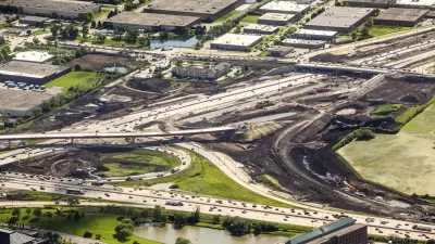
A proposed highway project in Florida, the Multi-use Corridors of Regional Economic Significance program, or M-CORES, has met with strong resistance from "a diverse cross section of opponents" who have called the proposed highways "roads to ruin."
Despite hopes that the three proposed highways "will help the state keep up with its explosive population growth," Eric Tegenhoff writes in a piece for Grist that groups from conservationists to taxpayer watchdogs have expressed concern about the project's cost and potential disruptions to wildlife habitats and rural economies.
The 330-mile toll road corridor could cost as much as $26 billion and, if completed, is projected to open by 2030. "In a year when lawmakers must reckon with the pandemic’s budget impact, the price tag for M-CORES is difficult for some critics to swallow." Meanwhile, environmental groups argue that new roads will just bring more traffic, encourage sprawl, and "disturb some of the state’s natural barriers against sea level rise, such as wetlands."
According to the Florida Department of Transportation (FDOT), the agency "will conduct financial and environmental feasibility studies when the agency chooses the most suitable path." In a statement sent to Grist, agency spokesperson Natalie McElwee wrote "A 'no-build' option remains on the table." An analysis by an opposition coalition calling itself No Roads to Ruin found that 93 percent of public comments sent to FDOT about the project were negative, "suggesting that there is little constituency for M-CORES."
FULL STORY: Basically everyone in Florida is united against these new highways

Highway Boondoggles Continue as the Pandemic Stresses Budgets at Every Level of Government
U.S. PIRG has released the latest edition of the Highway Boondoggles report, the sixth edition of the report published since 2014.

Proposed Toronto Highways Raise Environmental Concerns
Opponents of two new planned highways in greater Toronto argue the construction of new roads is 'short-sighted at best' and would threaten the region's greenbelt areas.
How Not to Do Growth
The state of Florida is moving forward with the Multi-use Corridors of Regional Economic Significance (M-Cores) plan to build several new toll expressways in rural parts of the state.

Maui's Vacation Rental Debate Turns Ugly
Verbal attacks, misinformation campaigns and fistfights plague a high-stakes debate to convert thousands of vacation rentals into long-term housing.

Planetizen Federal Action Tracker
A weekly monitor of how Trump’s orders and actions are impacting planners and planning in America.

In Urban Planning, AI Prompting Could be the New Design Thinking
Creativity has long been key to great urban design. What if we see AI as our new creative partner?

Pedestrian Deaths Drop, Remain Twice as High as in 2009
Fatalities declined by 4 percent in 2024, but the U.S. is still nowhere close to ‘Vision Zero.’

King County Supportive Housing Program Offers Hope for Unhoused Residents
The county is taking a ‘Housing First’ approach that prioritizes getting people into housing, then offering wraparound supportive services.

Researchers Use AI to Get Clearer Picture of US Housing
Analysts are using artificial intelligence to supercharge their research by allowing them to comb through data faster. Though these AI tools can be error prone, they save time and housing researchers are optimistic about the future.
Urban Design for Planners 1: Software Tools
This six-course series explores essential urban design concepts using open source software and equips planners with the tools they need to participate fully in the urban design process.
Planning for Universal Design
Learn the tools for implementing Universal Design in planning regulations.
planning NEXT
Appalachian Highlands Housing Partners
Mpact (founded as Rail~Volution)
City of Camden Redevelopment Agency
City of Astoria
City of Portland
City of Laramie