


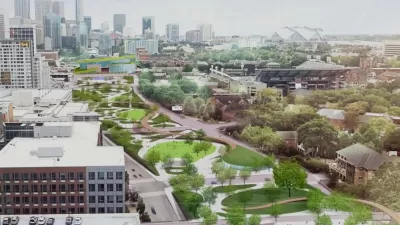
The billion-dollar project would create a 25-acre park and 3.5 miles of new bike and pedestrian routes.
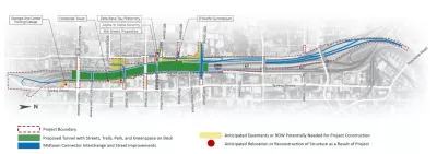
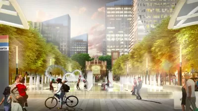
A proposed 25-acre park over Midtown Atlanta's I-75/I-85 freeway seeks to capitalize on the recent trend of "freeway caps" and reconnect neighborhoods torn apart by the interstate, writes Josh Green in Urbanize Atlanta. The project, expected to cost somewhere in the neighborhood of a billion dollars, is "an effort to boost park space for pedestrians and cyclists, enhance safety and street connectivity, improve air quality, and reintroduce both sides of the Connector as one conjoined Midtown community."
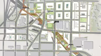
Backed by a non-profit partnership called the MCP Foundation, the park project "would require a range of public, philanthropic, and private dollars—and/or a possible new service tax district in the area around the park." The partnership has developed detailed plans for street upgrades, structural safety, new bicycle and pedestrian connections, and stormwater management for the 10-block stretch that would be affected.
The project could also improve safety in the busy corridor. According to its supporters, "by way of Connector exit reconfigurations, shoulder upgrades, and a new collector-distributor system, the project has the potential to reduce interstate crashes by 52 percent, travel delays by 37 percent in northbound lanes and 13 percent southbound, while slashing car collisions on Midtown streets by 15 percent."
FULL STORY: Glorious 10-block park floated for capping Atlanta's main highway

Atlanta Receives $3.2 Million for Freeway Cap Plan
The federal funding will help move forward planning for an ambitious proposal to cap a downtown Atlanta freeway with a 25-acre park.
Atlanta Freeway Cap Among Reconnecting Communities Awards
The infusion of $1.1 million in federal funding helps move the project along, but the total cost remains far beyond the city’s current budget.
Atlanta Launches Website for Highway Cap Project
Residents can view plans for the 14-acre project that include public plazas and green spaces connecting local landmarks, employment centers, and transit stations.

Maui's Vacation Rental Debate Turns Ugly
Verbal attacks, misinformation campaigns and fistfights plague a high-stakes debate to convert thousands of vacation rentals into long-term housing.

Planetizen Federal Action Tracker
A weekly monitor of how Trump’s orders and actions are impacting planners and planning in America.

San Francisco Suspends Traffic Calming Amidst Record Deaths
Citing “a challenging fiscal landscape,” the city will cease the program on the heels of 42 traffic deaths, including 24 pedestrians.

Defunct Pittsburgh Power Plant to Become Residential Tower
A decommissioned steam heat plant will be redeveloped into almost 100 affordable housing units.

Trump Prompts Restructuring of Transportation Research Board in “Unprecedented Overreach”
The TRB has eliminated more than half of its committees including those focused on climate, equity, and cities.

Amtrak Rolls Out New Orleans to Alabama “Mardi Gras” Train
The new service will operate morning and evening departures between Mobile and New Orleans.
Urban Design for Planners 1: Software Tools
This six-course series explores essential urban design concepts using open source software and equips planners with the tools they need to participate fully in the urban design process.
Planning for Universal Design
Learn the tools for implementing Universal Design in planning regulations.
Heyer Gruel & Associates PA
JM Goldson LLC
Custer County Colorado
City of Camden Redevelopment Agency
City of Astoria
Transportation Research & Education Center (TREC) at Portland State University
Jefferson Parish Government
Camden Redevelopment Agency
City of Claremont