


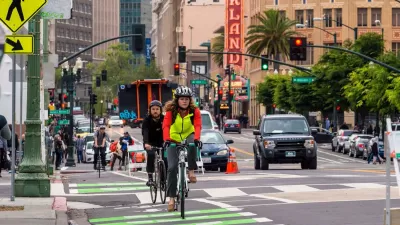
Suddenly, cars aren't the first priority on 10 percent of the roadway in Oakland, California.
[Headline and story updated on April 13, 2020 to better describe the "Oakland Slow Streets" program.]
"Cars will soon be banned from 74 miles of Oakland's residential streets during the coronavirus-inpsired [sic] shelter-in-place, a move bicycle advocates wish would happen in other cities," report Allie Rasmus and Lisa Fernandez.
"The emergency measure, called 'Oakland Slow Streets,' will banish motorized vehicles from 10% of the roadway space in Oakland," according to the article.
Update: cars will not be entirely banished from the streets. Rather, cars will be required to travel at no faster than 10 mph while giving priority to pedestrians and people on bikes, according ot additional information reported by Roger Rudick.
The Oakland Slow Streets program moves Oakland far into the lead of the national trend of cities blocking cars from streets to allow more space for pedestrians and people on bikes. Minneapolis previously opened 18 miles of streets.
Rachel Swan provides additional coverage of the Oakland Slow Streets program in a paywalled article for the San Francisco Chronicle.
FULL STORY: Oakland to close 74 miles of streets to cars, paving way for pedestrians and bicyclists

How Oakland Is Fixing its Pandemic Planning Equity Problem
The Oakland Slow Streets program, one of the most controversial developments of the early pandemic, has evolved to become the Essential Places initiative, thanks to new planning practices and a commitment to equity in Oakland, California.

Watch Oakland's Slow Streets Program in Action
Oakland offers a model for other streets looking to provide new space for pedestrians and people on bikes to get exercise at a space physical distance.
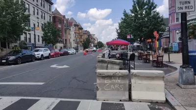
The Slow Streets Reckoning
Slow streets programs provided a quick short-term solution and paved the way for some permanent street closures and realignments. Now, these programs are getting a second look as community groups react to the changes.

Maui's Vacation Rental Debate Turns Ugly
Verbal attacks, misinformation campaigns and fistfights plague a high-stakes debate to convert thousands of vacation rentals into long-term housing.

Planetizen Federal Action Tracker
A weekly monitor of how Trump’s orders and actions are impacting planners and planning in America.

In Urban Planning, AI Prompting Could be the New Design Thinking
Creativity has long been key to great urban design. What if we see AI as our new creative partner?

How Trump's HUD Budget Proposal Would Harm Homelessness Response
Experts say the change to the HUD budget would make it more difficult to identify people who are homeless and connect them with services, and to prevent homelessness.

The Vast Potential of the Right-of-Way
One writer argues that the space between two building faces is the most important element of the built environment.

Florida Seniors Face Rising Homelessness Risk
High housing costs are pushing more seniors, many of them on a fixed income, into homelessness.
Urban Design for Planners 1: Software Tools
This six-course series explores essential urban design concepts using open source software and equips planners with the tools they need to participate fully in the urban design process.
Planning for Universal Design
Learn the tools for implementing Universal Design in planning regulations.
Gallatin County Department of Planning & Community Development
Heyer Gruel & Associates PA
JM Goldson LLC
City of Camden Redevelopment Agency
City of Astoria
Transportation Research & Education Center (TREC) at Portland State University
Jefferson Parish Government
Camden Redevelopment Agency
City of Claremont