


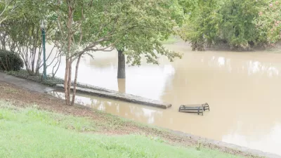
The Ohio Department of Transportation has prioritize the expansion of Interstate 71 in the neighborhood of Madisonville, in Cincinnati, over flood protection for property owners in the city, according to a recent city memo.
"The expansion and interchange changes on Interstate 71 near Madisonville have damaged part of Cincinnati’s flood protection system," reports Chris Wetterich.
That information was revealed in a city memo. "A portion of the city’s Duck Creek flood levee has been decertified by the U.S. Army Corps of Engineers until the state puts up a permanent replacement," according to Wetterich. "The city is telling property owners in the area that it no longer has the designed level of protection."
The Ohio Department of Transportation will build a new, permanent levee to replace the substandard temporary levee currently it's currently building, but the permanent replacement won't be completed until late in 2020.
FULL STORY: Highway project damages city flood control system

Fort Worth Spending More on Flood Control; Still Well Short of What’s Needed
Fort Worth could spend $136 million on stormwater infrastructure and flood control over the next five years. In all, the city needs more like $1 billion of investment.
Army Corps Pulls the Plug on $450 Million Mississippi Floodwater Project
A coalition of environmental scored a victory this month, when the U.S. Army Corps of Engineers canceled an expensive, and controversial, flood control project.
The Most Unsafe Road in Ohio: A Five-Mile Stretch of Interstate in Columbus
Traffic safety analysis inspires debate about the culprit (drivers or engineers?) on the least safe stretch of road in the Buckeye State.

Planetizen Federal Action Tracker
A weekly monitor of how Trump’s orders and actions are impacting planners and planning in America.

Restaurant Patios Were a Pandemic Win — Why Were They so Hard to Keep?
Social distancing requirements and changes in travel patterns prompted cities to pilot new uses for street and sidewalk space. Then it got complicated.

Map: Where Senate Republicans Want to Sell Your Public Lands
For public land advocates, the Senate Republicans’ proposal to sell millions of acres of public land in the West is “the biggest fight of their careers.”

Maui's Vacation Rental Debate Turns Ugly
Verbal attacks, misinformation campaigns and fistfights plague a high-stakes debate to convert thousands of vacation rentals into long-term housing.

San Francisco Suspends Traffic Calming Amidst Record Deaths
Citing “a challenging fiscal landscape,” the city will cease the program on the heels of 42 traffic deaths, including 24 pedestrians.

California Homeless Arrests, Citations Spike After Ruling
An investigation reveals that anti-homeless actions increased up to 500% after Grants Pass v. Johnson — even in cities claiming no policy change.
Urban Design for Planners 1: Software Tools
This six-course series explores essential urban design concepts using open source software and equips planners with the tools they need to participate fully in the urban design process.
Planning for Universal Design
Learn the tools for implementing Universal Design in planning regulations.
Heyer Gruel & Associates PA
JM Goldson LLC
Custer County Colorado
City of Camden Redevelopment Agency
City of Astoria
Transportation Research & Education Center (TREC) at Portland State University
Camden Redevelopment Agency
City of Claremont
Municipality of Princeton (NJ)