


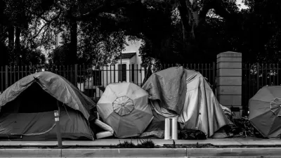
Records in Salt Lake City show that police in Salt Lake City concentrate jaywalking enforcement in the corner of the city that houses most of the city's homeless services.

Bethany Rodgers, Taylor Stevens, and Paighten Harkins report: "Nearly two out of every three jaywalking tickets Salt Lake City police issued in recent years have been handed out within roughly a block of Pioneer Park and the now-closed downtown emergency shelter — the hub of homeless services, a Salt Lake Tribune analysis has found."
More on the methodology and the implications of the analysis follows:
The Tribune’s findings, based on a review of more than 500 jaywalking tickets issued by city police in a four-year period through August, can’t be explained by heavy foot traffic alone, with only a smattering of tickets written in other busy parts of the city. Nor is the ticket pattern completely in line with state crash data, since enforcement was much lighter along some of the city’s most dangerous roads for pedestrians.
The findings of the analysis lend evidence to claims, frequently made by homeless advocacy groups, about the numerous ways that homelessness can be criminalized. The feature length article offers numerous anecdotes to provide specific, real-life examples of the dynamics exposed by the analysis.
FULL STORY: Targeting homeless? Most jaywalking tickets written near The Road Home and Pioneer Park.

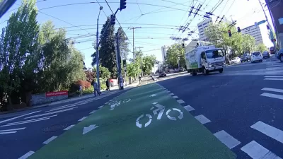
Seattle's Homeless Bearing the Brunt of Helmet Citations
Almost half of bike helmet citations in the city are issued to people experiencing homelessness.
Pedestrians Not Allowed Within Three Feet of Cars in Dayton
The new law is billed as a pedestrian safety measure, which is just one of the problems with the law according to critics.
Trump Wants to Force Homeless People Into ‘Tent Cities.’ Can He?
The president pushed for sweeping crackdowns and the possible internment of people experiencing homelessness. To see what's coming, we should look to what states have already done.

Maui's Vacation Rental Debate Turns Ugly
Verbal attacks, misinformation campaigns and fistfights plague a high-stakes debate to convert thousands of vacation rentals into long-term housing.

Planetizen Federal Action Tracker
A weekly monitor of how Trump’s orders and actions are impacting planners and planning in America.

San Francisco Suspends Traffic Calming Amidst Record Deaths
Citing “a challenging fiscal landscape,” the city will cease the program on the heels of 42 traffic deaths, including 24 pedestrians.

Defunct Pittsburgh Power Plant to Become Residential Tower
A decommissioned steam heat plant will be redeveloped into almost 100 affordable housing units.

Trump Prompts Restructuring of Transportation Research Board in “Unprecedented Overreach”
The TRB has eliminated more than half of its committees including those focused on climate, equity, and cities.

Amtrak Rolls Out New Orleans to Alabama “Mardi Gras” Train
The new service will operate morning and evening departures between Mobile and New Orleans.
Urban Design for Planners 1: Software Tools
This six-course series explores essential urban design concepts using open source software and equips planners with the tools they need to participate fully in the urban design process.
Planning for Universal Design
Learn the tools for implementing Universal Design in planning regulations.
Heyer Gruel & Associates PA
JM Goldson LLC
Custer County Colorado
City of Camden Redevelopment Agency
City of Astoria
Transportation Research & Education Center (TREC) at Portland State University
Jefferson Parish Government
Camden Redevelopment Agency
City of Claremont