


Maryland approved ambitious plans for public transit expansion around Baltimore in 2002, but almost none of it became a reality. With a new plan in the works, transit boosters assess the loss of a generation's worth of progress.
Josh Kurtz performs a post-mortem on the recent history of transit planning in the state of Maryland—almost all of which never came to fruition.
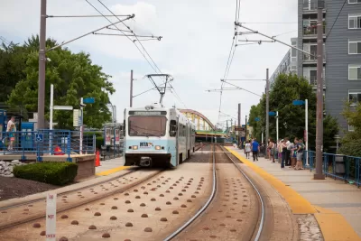
In 2002, Maryland transportation planners put the finishing touches on a proposal to dramatically expand mass transit in the state. The plan envisioned six new or improved transit lines, with 122 new transit station stops built over 40 years.
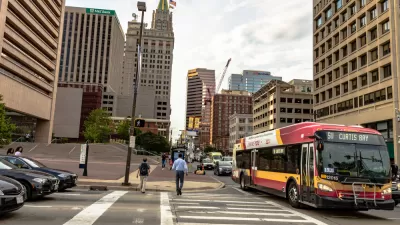
Today, only the Purple Line, a light rail project linking New Carrollton to Bethesda, survives. The Red Line, an east-west transit project in Baltimore, came close to final federal approval, but Gov. Lawrence J. Hogan Jr. (R) pulled the plug on the project in 2015.
The final nail in the coffin for those grand ambitions came in September when Maryland Governor Larry Hogan's administration announced that it would no longer prioritize the Corridor Cities Transitway, a bus rapid transit line in Montgomery County.
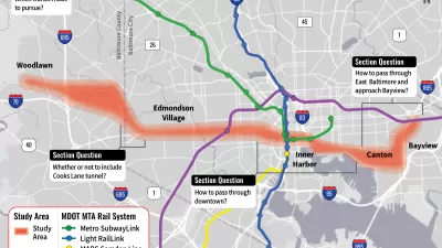
This post-mortem is set against the backdrop of a new transit planning study in the state, however: the Regional Transit Plan for Central Maryland. A draft plan is expected to be complete in a year, so the Greater Baltimore Committee and the Greater Washington Partnership recently held a public discussion on the future of transit in Maryland, but those in attendance couldn't avoid the past and the future.
As noted by Kurtz, several additional public forums on the Regional Transit Plan for Central Maryland are scheduled through the rest of the month.
FULL STORY: On Transit, Pondering What Might Be and Lamenting What Might Have Been

Central Maryland Regional Transit Plan: First Regional Transit Plan for Baltimore Since 2002
Transit planners in the Baltimore area are working on plans for a more reliable, useful regional transit system.
Maryland to Restart Planning for East-West Transit Line Through Baltimore
A plan for the Red Line, an east-west light rail line notoriously canceled by former-Governor Larry Hogan in 2015, is back on the table in Baltimore.
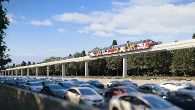
Monorail Study Moves Forward in Maryland
A plan to widen Interstate 270 in Maryland was approved earlier this year under the condition that the state also study a plan to build a monorail along the route.

Maui's Vacation Rental Debate Turns Ugly
Verbal attacks, misinformation campaigns and fistfights plague a high-stakes debate to convert thousands of vacation rentals into long-term housing.

Planetizen Federal Action Tracker
A weekly monitor of how Trump’s orders and actions are impacting planners and planning in America.

In Urban Planning, AI Prompting Could be the New Design Thinking
Creativity has long been key to great urban design. What if we see AI as our new creative partner?

Chicago’s Ghost Rails
Just beneath the surface of the modern city lie the remnants of its expansive early 20th-century streetcar system.

Baker Creek Pavilion: Blending Nature and Architecture in Knoxville
Knoxville’s urban wilderness planning initiative unveils the "Baker Creek Pavilion" to increase the city's access to green spaces.

Pedestrian Deaths Drop, Remain Twice as High as in 2009
Fatalities declined by 4 percent in 2024, but the U.S. is still nowhere close to ‘Vision Zero.’
Urban Design for Planners 1: Software Tools
This six-course series explores essential urban design concepts using open source software and equips planners with the tools they need to participate fully in the urban design process.
Planning for Universal Design
Learn the tools for implementing Universal Design in planning regulations.
planning NEXT
Appalachian Highlands Housing Partners
Mpact (founded as Rail~Volution)
City of Camden Redevelopment Agency
City of Astoria
City of Portland
City of Laramie