


Cutting the board of the San Francisco Municipal Transportation Agency out of the approvals process for implementing bike lanes in San Francisco could shave three months off the delivery schedule.
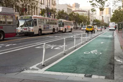
"San Francisco may soon tear up the red tape delaying the construction of some protected bike lanes," reports Joe Fitzgerald Rodriguez.
"A proposal up for approval Tuesday by the San Francisco Municipal Transportation Agency Board of Directors would give city staff the authority to create 'quick build' protected bike lanes without the approval of the SFMTA board," Rodriguez adds to explain the proposal.
"Staff would also be empowered to enact other street changes without going before the SFMTA board, including creating transit boarding islands, designating blue and red parking zones, establishing stop signs, prohibiting right, left or U-turns, establishing restrictions against red-light turns, and establishing multiple turn lanes."
Rodriguez provides additional background on the political support from the idea, originating from the office of Mayor London Breed, and with the support of local bike advocacy organizations. There is also already a long list of corridors that could soon get the "quick-build" treatment.
FULL STORY: SF to streamline approvals for protected bike lanes, other safety improvements

Survey Says New Yorker Want More Protected Bike and Bus Lanes, Less Parking
A new survey reveals broad support for a less car-centric approach to capital investment in the city of New York.
It Takes a Fatality to Remove On-Street Parking
On March 8, 30-year-old Tess Rothstein of Berkeley was riding a rented Ford GoBike in San Francisco's SoMa district when a car door suddenly opened, forcing her outside the narrow white line of the conventional bike lane into the path of a truck.

Protected Bike Lane Plan Shelved in San Francisco
Bike advocates say a protected bike lane near the downtown Caltrain station can't wait. The San Francisco Municipal Transportation Agency (SFMTA) says the project will have to wait.

Maui's Vacation Rental Debate Turns Ugly
Verbal attacks, misinformation campaigns and fistfights plague a high-stakes debate to convert thousands of vacation rentals into long-term housing.

Planetizen Federal Action Tracker
A weekly monitor of how Trump’s orders and actions are impacting planners and planning in America.

In Urban Planning, AI Prompting Could be the New Design Thinking
Creativity has long been key to great urban design. What if we see AI as our new creative partner?

How Trump's HUD Budget Proposal Would Harm Homelessness Response
Experts say the change to the HUD budget would make it more difficult to identify people who are homeless and connect them with services, and to prevent homelessness.

The Vast Potential of the Right-of-Way
One writer argues that the space between two building faces is the most important element of the built environment.

Florida Seniors Face Rising Homelessness Risk
High housing costs are pushing more seniors, many of them on a fixed income, into homelessness.
Urban Design for Planners 1: Software Tools
This six-course series explores essential urban design concepts using open source software and equips planners with the tools they need to participate fully in the urban design process.
Planning for Universal Design
Learn the tools for implementing Universal Design in planning regulations.
Gallatin County Department of Planning & Community Development
Heyer Gruel & Associates PA
JM Goldson LLC
City of Camden Redevelopment Agency
City of Astoria
Transportation Research & Education Center (TREC) at Portland State University
Jefferson Parish Government
Camden Redevelopment Agency
City of Claremont