


Pedestrians are often blamed first for accidents, but they have few choices when the infrastructure is lacking, a new study shows.
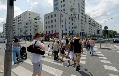
Michael Smith, a University of Illinois graduate student, collected video at intersections on a road in Rockford, Illinois, to understand better how pedestrians interact with the built environment. Often pedestrians are blamed for accidents, with the assumption being that they were jaywalking or not paying attention to their surroundings.
"But Smith’s videos found pedestrians’ behavior is influenced a lot by the environment: They’re more likely engage in risky behavior — like walking or rolling in the street or crossing mid-block — when the pedestrian infrastructure is incomplete or lacking," reports Angie Schmitt.
At one intersection, Smith repeatedly saw examples of people backtracking and going into the street because there was not an ADA-compliant ramp at the corner, even though the location was near a housing development for older people. He also noticed that people waiting for buses at a stop without a bench or shelter would wait on the other side of the street at a shopping center and then dart across when the bus came.
"People were adapting their behavior to the conditions, often in ways that put them at risk," notes Schmitt. Smith’s recommendations include a decrease in the speed limit, enhanced crosswalks, and leading pedestrian intervals at signaled intersections.
FULL STORY: Research Explains Why Pedestrians ‘Break the Rules’

US Street Design Manual Inches Toward Safer Roads
The guiding document for U.S. road design is starting to recognize the needs of people walking and biking, but safe streets advocates say more significant changes are needed to reduce the high number of pedestrian deaths and improve connectivity for all road users.
Traffic Safety Efforts Chug Ahead — Too Slowly for Some
Around the United States, traffic deaths are growing or plateauing, yet efforts to make roads safer still face political opposition.
The Vicious Cycle at the Heart of Pedestrian Safety
When people feel unsafe, they walk less; with fewer pedestrians, walking becomes less safe.

Planetizen Federal Action Tracker
A weekly monitor of how Trump’s orders and actions are impacting planners and planning in America.

Maui's Vacation Rental Debate Turns Ugly
Verbal attacks, misinformation campaigns and fistfights plague a high-stakes debate to convert thousands of vacation rentals into long-term housing.

Restaurant Patios Were a Pandemic Win — Why Were They so Hard to Keep?
Social distancing requirements and changes in travel patterns prompted cities to pilot new uses for street and sidewalk space. Then it got complicated.

In California Battle of Housing vs. Environment, Housing Just Won
A new state law significantly limits the power of CEQA, an environmental review law that served as a powerful tool for blocking new development.

Boulder Eliminates Parking Minimums Citywide
Officials estimate the cost of building a single underground parking space at up to $100,000.

Orange County, Florida Adopts Largest US “Sprawl Repair” Code
The ‘Orange Code’ seeks to rectify decades of sprawl-inducing, car-oriented development.
Urban Design for Planners 1: Software Tools
This six-course series explores essential urban design concepts using open source software and equips planners with the tools they need to participate fully in the urban design process.
Planning for Universal Design
Learn the tools for implementing Universal Design in planning regulations.
Heyer Gruel & Associates PA
JM Goldson LLC
Custer County Colorado
City of Camden Redevelopment Agency
City of Astoria
Transportation Research & Education Center (TREC) at Portland State University
Jefferson Parish Government
Camden Redevelopment Agency
City of Claremont