


The A and G Lines use GPS for their crossing gates, they claim that a new software patch and other improvements would resolve those issues and put the G line on schedule.
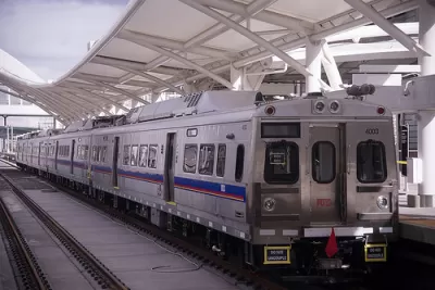
Denver's crossing gates have caused a series of headaches for the city’s transit system. Now the Regional Transportation District (RTD) says the problem is tied to blocked GPS signals. “The document said Denver’s rising skyline around Union Station regularly blocks GPS signals the system relies on to keep the University of Colorado A-Line running smoothly and safely,” John Aguilar writes for the Denver Post. RTD says they have a software patch to fix this issue that they can put into place quickly if the plan is approved at the federal level. “RTD says it is ready to open the long-delayed G-Line to Denver’s western suburbs in the first quarter of 2019 if the Federal Railroad Administration accepts its action plan,” Aguilar reports.
The use of GPS also features in the federally mandated safety feature known as positive train control (PTC). While operators do not currently need to employ PTC, the due date is coming up. RTD officials say they will be ready. Some observers have pointed out that many of the transit systems around the world are in cities with more tall buildings than Denver, without experiencing similar issues.
FULL STORY: Denver’s tall buildings partly to blame for A-Line, G-Line problems, RTD tells feds

New Colorado Fossil Fuel Fee Will Fund Transit
Lawmakers say the agreement prevents a drawn-out legislative battle and establishes a new source of transit funding.
Denver-Area Rail Service Disruptions Expected During Maintenance Work
RTD is beginning maintenance on retaining walls along its southeastern light rail lines that is expected to last roughly six months.

Denver Transit Proposal Could Lower Fares, Make Transit Free for Youth
The agency released a draft plan to eliminate regional zones, make airport trips more affordable, and reduce fares systemwide.

Maui's Vacation Rental Debate Turns Ugly
Verbal attacks, misinformation campaigns and fistfights plague a high-stakes debate to convert thousands of vacation rentals into long-term housing.

Planetizen Federal Action Tracker
A weekly monitor of how Trump’s orders and actions are impacting planners and planning in America.

San Francisco Suspends Traffic Calming Amidst Record Deaths
Citing “a challenging fiscal landscape,” the city will cease the program on the heels of 42 traffic deaths, including 24 pedestrians.

Defunct Pittsburgh Power Plant to Become Residential Tower
A decommissioned steam heat plant will be redeveloped into almost 100 affordable housing units.

Trump Prompts Restructuring of Transportation Research Board in “Unprecedented Overreach”
The TRB has eliminated more than half of its committees including those focused on climate, equity, and cities.

Amtrak Rolls Out New Orleans to Alabama “Mardi Gras” Train
The new service will operate morning and evening departures between Mobile and New Orleans.
Urban Design for Planners 1: Software Tools
This six-course series explores essential urban design concepts using open source software and equips planners with the tools they need to participate fully in the urban design process.
Planning for Universal Design
Learn the tools for implementing Universal Design in planning regulations.
Heyer Gruel & Associates PA
JM Goldson LLC
Custer County Colorado
City of Camden Redevelopment Agency
City of Astoria
Transportation Research & Education Center (TREC) at Portland State University
Jefferson Parish Government
Camden Redevelopment Agency
City of Claremont