


The program’s outcomes in different cities show varying levels of success and some failures.

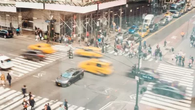
Laura Laker takes a closer look at Vision Zero, a traffic safety program designed to decrease, and ultimately eliminate, traffic deaths and injuries. In 2014, New York was the first large American city to adopt a Vision Zero program. The city lowered traffic speeds on particularly dangerous streets, installed features that slowed traffic, and put in speed cameras. Road fatalities decreased by over 25 percent and pedestrian deaths by almost 50 percent by 2017.
Los Angeles, on the other hand, ran into problems when it started up a Vision Zero program last year, and road fatalities eventually increased by 80 percent, reports Laker:
On Temple Street, where 34 people were killed or severely injured within 2.3 miles in eight years, a “road diet” expected to reduce crashes by up to 47% met backlash from residents and drivers. Local city leaders downgraded lane removals to things that wouldn’t interfere with motor traffic: sidewalk repairs, new traffic signals and crosswalks.
London recently adopted its own Vision Zero plan, and it is also facing resistance. “In June, mayor Sadiq Khan’s flagship pedestrian safety scheme, the pedestrianisation of Oxford Street, was blocked by the local borough, Westminster city council, following local concerns about traffic displacement,” says Laker.
Advocates say Vision Zero programs need strong political leadership to push through the kinds of infrastructure and design changes necessary for creating a safer urban landscape. In addition, policing needs to focus more on drivers and less on pedestrians and cyclists, they say.
FULL STORY: Vision Zero: has the drive to eliminate road deaths lost its way?

NYC Pedestrian Deaths Rose in 2024
The city’s Vision Zero efforts seem to have stalled.

Rebuilding From the Failures of Vision Zero
Vision Zero pledges in New York City and Washington, D.C. have failed to slow the carnage on streets and roads—traffic fatalities are only increasing. It's time to start over.
The Pandemic's Traffic Safety Crisis, Explained
It's another one of those crises within a crisis, but driving has been more dangerous during the pandemic.

Maui's Vacation Rental Debate Turns Ugly
Verbal attacks, misinformation campaigns and fistfights plague a high-stakes debate to convert thousands of vacation rentals into long-term housing.

Planetizen Federal Action Tracker
A weekly monitor of how Trump’s orders and actions are impacting planners and planning in America.

In Urban Planning, AI Prompting Could be the New Design Thinking
Creativity has long been key to great urban design. What if we see AI as our new creative partner?

King County Supportive Housing Program Offers Hope for Unhoused Residents
The county is taking a ‘Housing First’ approach that prioritizes getting people into housing, then offering wraparound supportive services.

Researchers Use AI to Get Clearer Picture of US Housing
Analysts are using artificial intelligence to supercharge their research by allowing them to comb through data faster. Though these AI tools can be error prone, they save time and housing researchers are optimistic about the future.

Making Shared Micromobility More Inclusive
Cities and shared mobility system operators can do more to include people with disabilities in planning and operations, per a new report.
Urban Design for Planners 1: Software Tools
This six-course series explores essential urban design concepts using open source software and equips planners with the tools they need to participate fully in the urban design process.
Planning for Universal Design
Learn the tools for implementing Universal Design in planning regulations.
planning NEXT
Appalachian Highlands Housing Partners
Mpact (founded as Rail~Volution)
City of Camden Redevelopment Agency
City of Astoria
City of Portland
City of Laramie