


CityLab University tackles a widely misunderstood concept: induced demand.
CityLab University endeavors to provide clear explanations of some of the "most important concepts related to cities and urban policy." A previous post explained inclusionary zoning, for instance. For the most recent post, Benjamin Schneider explains the concept of induced demand, or why new road capacity doesn't reduce traffic.
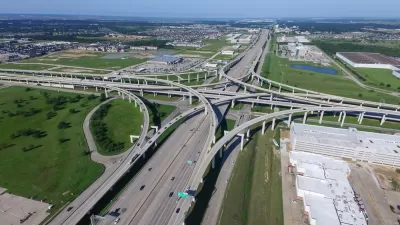
Launching the explanation with the example of the Katy Freeway in Houston, which has 26 lanes at its widest point, and still sees worsening congestion.
The idea that the Katy Freeway could expand to such capacity and still see regular congestion is explained by induced demand. While Schneider goes into a lot more detail in the source article, here are the key points that organize the article:
- In urbanism, “induced demand” refers to the idea that increasing roadway capacity encourages more people to drive, thus failing to improve congestion.
- Since the concept was introduced in the 1960s, numerous academic studies have demonstrated the existence of ID.
- But some economists argue that the effects of ID are overstated, or outweighed by the benefits of greater automobility.
- Few federal, state, and local departments of transportation are thought to adequately account for ID in their long-term planning.
FULL STORY: CityLab University: Induced Demand


Speck: Don't Widen I-45 in Houston
Jeff Speck, planning consultant and author of Walkable City, writes an opinion piece for the Houston Chronicle to oppose the plan to widen the I-45 freeway in Houston.

Op-Ed: 'Public Mood' Has Turned Against Cars in Cities
A survey of recent planning decisions demonstrates that cities are no longer necessarily looking to more and bigger highways to solve their traffic problems.

Too Big for Texas? Houston's 23-Lane Freeway
After a $2.3 billion widening project, traffic once again chokes the Katy Freeway's 23 lanes. For road spending critics who are also taxpayers, this I-told-you-so moment is bittersweet.

Planetizen Federal Action Tracker
A weekly monitor of how Trump’s orders and actions are impacting planners and planning in America.

Maui's Vacation Rental Debate Turns Ugly
Verbal attacks, misinformation campaigns and fistfights plague a high-stakes debate to convert thousands of vacation rentals into long-term housing.

Restaurant Patios Were a Pandemic Win — Why Were They so Hard to Keep?
Social distancing requirements and changes in travel patterns prompted cities to pilot new uses for street and sidewalk space. Then it got complicated.

In California Battle of Housing vs. Environment, Housing Just Won
A new state law significantly limits the power of CEQA, an environmental review law that served as a powerful tool for blocking new development.

Boulder Eliminates Parking Minimums Citywide
Officials estimate the cost of building a single underground parking space at up to $100,000.

Orange County, Florida Adopts Largest US “Sprawl Repair” Code
The ‘Orange Code’ seeks to rectify decades of sprawl-inducing, car-oriented development.
Urban Design for Planners 1: Software Tools
This six-course series explores essential urban design concepts using open source software and equips planners with the tools they need to participate fully in the urban design process.
Planning for Universal Design
Learn the tools for implementing Universal Design in planning regulations.
Heyer Gruel & Associates PA
JM Goldson LLC
Custer County Colorado
City of Camden Redevelopment Agency
City of Astoria
Transportation Research & Education Center (TREC) at Portland State University
Jefferson Parish Government
Camden Redevelopment Agency
City of Claremont