


Transit planners with the Los Angeles County Metropolitan Transportation Authority have recommended light rail for the planned East San Fernando Valley Transit Corridor Project.
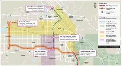
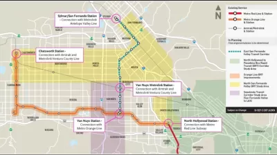
Los Angeles Metro staff recently completed a draft Environmental Impact Statement/Environmental Impact Report on the East San Fernando Valley Transit Corridor Project. The draft EIS/EIR recommends a 9.5-mile light rail route connecting the Sylmar/San Fernando Metrolink Station to the Metro Orange Line via Van Nuys Boulevard and San Fernando Road.
Antonio Pacheco reports on the details of the planned project, noting its potential to transform transit infrastructure San Fernando Valley, currently including two subway stops and a bus rapid transit corridor in addition to typical bus service. "With a bit of luck, the proposed route also has the potential to definitively link the valley with the rest of Los Angeles, depending on which alignment is chosen for other forthcoming high-profile project routes," reports Pacheco, referring to the Sepulveda Pass project, which could someday connect the valley to the city's Westside along the I-405 alignment.
The Metro Board is expected to consider the recommendations of the draft EIR/EIS before the end of the month.
FULL STORY: L.A. is one step closer to bringing light rail to the San Fernando Valley

Funding for Two Transit Projects Approved for the Valley in Los Angeles
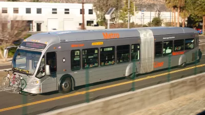
Local funding for a new light rail line and upgrades to the G Line (née Orange Line) bus rapid transit route have been approved for the San Fernando Valley in Los Angeles.

Environmental Review for Light Rail Through The Valley Approved
The B Line subway includes two stops in the San Fernando Valley in Los Angeles, but other than that, commuter rail and buses are the only options for transit. New light rail plans could change that.
$1.9 Billion in State Budget Surplus Requested for L.A. Transit Projects
L.A. transit officials hope the state budget surplus can be used to fund regional transit project, including one highly anticipated light rail project that broke ground on Friday, December 2.

Planetizen Federal Action Tracker
A weekly monitor of how Trump’s orders and actions are impacting planners and planning in America.

Maui's Vacation Rental Debate Turns Ugly
Verbal attacks, misinformation campaigns and fistfights plague a high-stakes debate to convert thousands of vacation rentals into long-term housing.

San Francisco Suspends Traffic Calming Amidst Record Deaths
Citing “a challenging fiscal landscape,” the city will cease the program on the heels of 42 traffic deaths, including 24 pedestrians.

Amtrak Rolls Out New Orleans to Alabama “Mardi Gras” Train
The new service will operate morning and evening departures between Mobile and New Orleans.

The Subversive Car-Free Guide to Trump's Great American Road Trip
Car-free ways to access Chicagoland’s best tourist attractions.

San Antonio and Austin are Fusing Into one Massive Megaregion
The region spanning the two central Texas cities is growing fast, posing challenges for local infrastructure and water supplies.
Urban Design for Planners 1: Software Tools
This six-course series explores essential urban design concepts using open source software and equips planners with the tools they need to participate fully in the urban design process.
Planning for Universal Design
Learn the tools for implementing Universal Design in planning regulations.
Heyer Gruel & Associates PA
JM Goldson LLC
Custer County Colorado
City of Camden Redevelopment Agency
City of Astoria
Transportation Research & Education Center (TREC) at Portland State University
Jefferson Parish Government
Camden Redevelopment Agency
City of Claremont