


The B Line subway includes two stops in the San Fernando Valley in Los Angeles, but other than that, commuter rail and buses are the only options for transit. New light rail plans could change that.
The Los Angeles County Metropolitan Transportation Authority's (Metro) Board of Directors recently voted to certify the final Environmental Impact Review (EIR) for a light rail route that will run north-south through the San Fernando Valley (The Valley) in Los Angeles, according to an article by Dave Sotero for Metro's The Source.
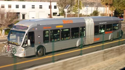
The planned East San Fernando Light Rail Project would connect the G Line bus rapid transit route (formerly known as the Orange Line) to the Sylmar/San Fernando Metrolink Station, with 14 stations built along the way.
The project would be funded by Measure M locally, along with Prop 1B funding from the state of California, "and could be well-positioned to compete if any federal funding opportunities become available," according to Sotero.
According to Sotero, the EIR approved by the Metro Board includes provisions that will enable the route to be built in segments, starting potentially as early as next year on the first 6.7-mile segment between the G Line in Van Nuys to San Fernando Road in Pacoima.
FULL STORY: Metro Board approves Final EIR for East San Fernando Valley Light Rail Transit Project

Funding for Two Transit Projects Approved for the Valley in Los Angeles
Local funding for a new light rail line and upgrades to the G Line (née Orange Line) bus rapid transit route have been approved for the San Fernando Valley in Los Angeles.

Light Rail Proposal for L.A.'s San Fernando Valley Wins Key Approval
Light rail could come to "The Valley" for the first time, under a plan approved this week by the Los Angeles County Metropolitan Transportation Authority's Board of Directors.
L.A.'s San Fernando Valley $909 Million Closer to Light Rail
The last time rail transit crossed L.A.'s San Fernando Valley was in the early 1950s.

Maui's Vacation Rental Debate Turns Ugly
Verbal attacks, misinformation campaigns and fistfights plague a high-stakes debate to convert thousands of vacation rentals into long-term housing.

Planetizen Federal Action Tracker
A weekly monitor of how Trump’s orders and actions are impacting planners and planning in America.

In Urban Planning, AI Prompting Could be the New Design Thinking
Creativity has long been key to great urban design. What if we see AI as our new creative partner?

King County Supportive Housing Program Offers Hope for Unhoused Residents
The county is taking a ‘Housing First’ approach that prioritizes getting people into housing, then offering wraparound supportive services.

Researchers Use AI to Get Clearer Picture of US Housing
Analysts are using artificial intelligence to supercharge their research by allowing them to comb through data faster. Though these AI tools can be error prone, they save time and housing researchers are optimistic about the future.

Making Shared Micromobility More Inclusive
Cities and shared mobility system operators can do more to include people with disabilities in planning and operations, per a new report.
Urban Design for Planners 1: Software Tools
This six-course series explores essential urban design concepts using open source software and equips planners with the tools they need to participate fully in the urban design process.
Planning for Universal Design
Learn the tools for implementing Universal Design in planning regulations.
planning NEXT
Appalachian Highlands Housing Partners
Mpact (founded as Rail~Volution)
City of Camden Redevelopment Agency
City of Astoria
City of Portland
City of Laramie