


A new book of maps, photographs, and essays considers the rich historic legacy of land use and transportation on and around the Great Lakes.
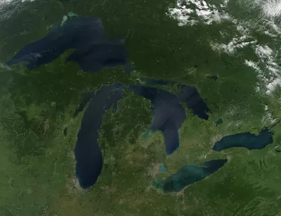
The Great Lakes. Major architecture and landscape architecture ideas were tested here. The car gained prominence here. Ports gained prominence here. Edited by Charles Waldheim, Mason White, Clare Lyster, and Daniel Ibanez, the Third Coast Atlas is a cartographic and photographic essay of where the area around the Great Lakes has come from and where it stands today.
The Third Coast Atlas discusses many topics dealing with the Great Lakes through history, ranging from geology to early trade, and today's struggling rust belt cities. It also looks to the future with ideas like a "Free Water Zone," a mixed-use district where users can take free water from the Great Lakes for industrial uses as long as they return it in pristine condition.
FULL STORY: The Story of the Great Lakes in 8 Maps

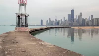
Lessons From the Viral Video of Lake Michigan Taking Out a Bike Commuter
Climate change will only increase the frequency of incidents like the one captured by a television news station in Chicago earlier this week.
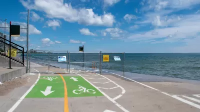
Lake Michigan Wreaking Havoc on Chicago This Summer
Lake Michigan has reached historic levels this summer. Properties on the Far North Side are most at risk. Swimmers have already been called back from the shore.
Gertrude Kerbis, Pioneering Female Architect
Architect Gertrude Kerbis worked for sixty years designing buildings in Chicago alongside more famous architects like Walter Gropius and Mies Van der Rohe. Preservation Magazine talks to her about her struggles as a woman in a male-dominated field.

Planetizen Federal Action Tracker
A weekly monitor of how Trump’s orders and actions are impacting planners and planning in America.

Restaurant Patios Were a Pandemic Win — Why Were They so Hard to Keep?
Social distancing requirements and changes in travel patterns prompted cities to pilot new uses for street and sidewalk space. Then it got complicated.

Maui's Vacation Rental Debate Turns Ugly
Verbal attacks, misinformation campaigns and fistfights plague a high-stakes debate to convert thousands of vacation rentals into long-term housing.

In California Battle of Housing vs. Environment, Housing Just Won
A new state law significantly limits the power of CEQA, an environmental review law that served as a powerful tool for blocking new development.

Boulder Eliminates Parking Minimums Citywide
Officials estimate the cost of building a single underground parking space at up to $100,000.

Orange County, Florida Adopts Largest US “Sprawl Repair” Code
The ‘Orange Code’ seeks to rectify decades of sprawl-inducing, car-oriented development.
Urban Design for Planners 1: Software Tools
This six-course series explores essential urban design concepts using open source software and equips planners with the tools they need to participate fully in the urban design process.
Planning for Universal Design
Learn the tools for implementing Universal Design in planning regulations.
Heyer Gruel & Associates PA
JM Goldson LLC
Custer County Colorado
City of Camden Redevelopment Agency
City of Astoria
Transportation Research & Education Center (TREC) at Portland State University
Camden Redevelopment Agency
City of Claremont
Municipality of Princeton (NJ)