


Technology
Meet Flow: Google's Transportation Data Revolution
Alphabet's Sidewalk Labs is readying a product called Flow to help cities and counties make the most of transportation data. The news is another step along the path to a future version of transportation.
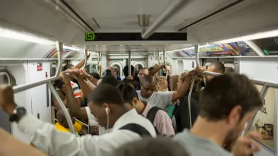
New York Subway Service Lags as Ridership Grows
Increasing ridership, coupled with decreasing service, means a very crowded subway system in New York City.
A Detroit Design School Seeks a Seat at the Table
Academic institutions can play a major role in enriching the communities they operate in. Amy Deines, interim dean of the College of Architecture and Design at Lawrence Technological University in Detroit, discusses the city and school's trajectory.
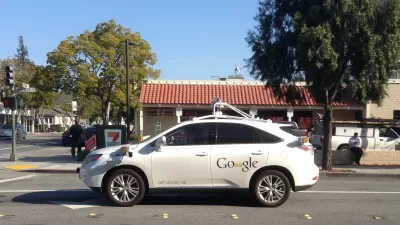
No Business as Usual in an Autonomous Vehicle Future
Among the reasons to reconsider new investments in expanded roadway capacity: the impending revolution in transportation that will arrive when cars start driving themselves.

U.S. Won Space Race but Lost High Speed Rail Race
The U.S. ranked 19 out of 20 for countries with high speed rail service according to a new survey by GoEuro.
Anchorage Updates Land Use Plan Map
After 34 years the Municipality of Anchorage is updating its land use plan map, a companion piece to its comprehensive plan adopted in 2001. The land use plan map sets the stage for future growth and development in this Northern City of 301,000.

U.S. DOT Making a National Transit Map
Transportation Secretary Antony Foxx called on local transit agencies earlier this month to share data to be used in building a comprehensive map of the nation's transit lines.
'Drive Clean Seattle' Would Put 15,000 Electric Cars on The Road
Mayor Ed Murray will start with Seattle's own fleet in replacing existing buses, cars, and trucks with electric vehicles.
Humanizing Tech in New York City
Rapid technological change has brought incredible opportunities as well as challenges to cities around the world. NYC's Chief Technology Officer and Director of Innovation discuss how the City is leveraging technology for improving city life.
How Gaming Can Revolutionize Planning
The new game Block’Hood seeks to illustrate and educate about the connection between sustainability and social and economic needs in city and neighborhood building.
Automotive Braking Improvements: Pedestrian and Cyclist Benefits Included
NHTSA's announcement that automatic emergency braking will become standard on almost all new vehicles by 2022 will have dramatic safety implications for drivers and passengers, but will it prevent crashes with pedestrians and cyclists?

Alternative Infrastructure: Electrified Roads
The concept is no different from trains travelling along a charged track. While any real-world implementation is a long way off, the TEV team is building a trial road for a lower estimated cost per mile than traditional highway.
Technology Companies Selected for California Road Charge Pilot
California's Road Charge Pilot Program is set to start this July. Applications for the 5,000 volunteers are being collected. Three companies hope to entice participants to select their programs by offering them 'high-tech perks.'
Sticking Together Could Pay With Truck Platooning Technology
Autonomous cars are making headlines, but what about using automated platooning technology for truck fleets or the military? The technology may be able to cut fuel costs and allow for the driverless transport of goods through dangerous areas.
Feds Worried About Car Hacking
As cars become more and more technologically advanced, a trio of federal agencies this week put out a public service announcement about the dangers of car hacking.
Uber for Trucking: Matching Freight with Haulers
Finding freight to haul—or truckers to move merchandise—is as easy as logging into one of many so-called "Uber for trucking" smartphone applications on the market.
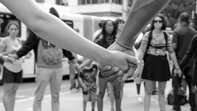
Does Ride-Hailing Complement Public Transit—Or Vice Versa?
Thanks to technology-enabled ride-hailing services, more households have the ability to go car-lite now than in preceding generations, according to a new study prepared for the American Public Transportation Association.
Empowered Design, By 'The Crowd'
Crowdsourcing offers a viable resource for planners to empower communities and engage citizens to collectively innovate solutions to complex urban problems.
What If Planners Had a Tool for Predicting Outcomes?
Or, put another way, what if planners could make unintended consequences a relic of the past?
The E-commerce Revolution
The internet has revolutionized the way people shop. From Amazon's Prime service, to grocery stores offering online ordering and delivery or store pick-up, the retail landscape has changed and so have brick-and-mortar shops and delivery methods.
Urban Design for Planners 1: Software Tools
This six-course series explores essential urban design concepts using open source software and equips planners with the tools they need to participate fully in the urban design process.
Planning for Universal Design
Learn the tools for implementing Universal Design in planning regulations.
Heyer Gruel & Associates PA
JM Goldson LLC
Custer County Colorado
City of Camden Redevelopment Agency
City of Astoria
Transportation Research & Education Center (TREC) at Portland State University
Jefferson Parish Government
Camden Redevelopment Agency
City of Claremont


