


Transportation Secretary Antony Foxx called on local transit agencies earlier this month to share data to be used in building a comprehensive map of the nation's transit lines.
Faiz Siddiqui reports on the goals of the National Transit Map, i.e., "a nationwide effort to cull data from transit agencies into a comprehensive feed for anyone to use."
The initiative launched on March 8, with data collection scheduled to begin on March 31, according to a U.S. Department of Transportation website announcing the project.
According to Siddiqui, the initiative is intended to help pinpoint transit deserts, and "use the information to help persuade policymakers to improve public transportation in underserved communities."
The article includes more of the technical details of the data request, potential applications of the data the U.S. DOT hopes to collect in the process, and more background on the nation's transit deserts and their impacts on economic mobility.
FULL STORY: How a National Transit Map could connect ‘transit deserts’ to the grid


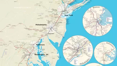
Hot Off the Press: The National Transit Map
The U.S. Department of Transit has released its first ever National Transit Map.

Where USDOT Awarded $3.2 Billion in Grants
The department announced awards for projects that include intercity rail, low-emission buses, and tech-driven transit improvements.

Beyond Congestion Pricing: Strategies for Revolutionizing Urban Mobility
How cities are leveraging data and technology to improve their transportation networks and reduce traffic.

Maui's Vacation Rental Debate Turns Ugly
Verbal attacks, misinformation campaigns and fistfights plague a high-stakes debate to convert thousands of vacation rentals into long-term housing.

Planetizen Federal Action Tracker
A weekly monitor of how Trump’s orders and actions are impacting planners and planning in America.

Chicago’s Ghost Rails
Just beneath the surface of the modern city lie the remnants of its expansive early 20th-century streetcar system.

Bend, Oregon Zoning Reforms Prioritize Small-Scale Housing
The city altered its zoning code to allow multi-family housing and eliminated parking mandates citywide.

Amtrak Cutting Jobs, Funding to High-Speed Rail
The agency plans to cut 10 percent of its workforce and has confirmed it will not fund new high-speed rail projects.

LA Denies Basic Services to Unhoused Residents
The city has repeatedly failed to respond to requests for trash pickup at encampment sites, and eliminated a program that provided mobile showers and toilets.
Urban Design for Planners 1: Software Tools
This six-course series explores essential urban design concepts using open source software and equips planners with the tools they need to participate fully in the urban design process.
Planning for Universal Design
Learn the tools for implementing Universal Design in planning regulations.
planning NEXT
Appalachian Highlands Housing Partners
Mpact (founded as Rail~Volution)
City of Camden Redevelopment Agency
City of Astoria
City of Portland
City of Laramie