


Technology
Coming this Summer: Airbnb Will Collect Taxes in San Francisco, New York State
The ongoing saga of the tax and regulatory standing of Airbnb, the popular room rental app and poster child for the sharing economy, is evolving in San Francisco, Portland and the state of New York.
The History of GPS—Back to the First Century
A new book details the primitive origins of the GPS tracking technologies that are so pervasive in today’s mobile-phone-enabled world.
Real-Time Multi-Modal Way-Finding—Displayed in the Public Realm
The TransitScreen service has been around since 2012, but it’s latest product, real-time displays of all modes of transportation, can display in the public realm, providing a whole new level of interaction with the city.
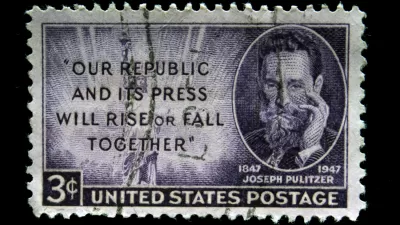
Pulitzer Prizes Awarded for Urbanism and Built Environment Journalism
The 2014 Pulitzer Prizes yesterday awarded the best work of journalists over the past year. Included in the roster of winners were journalists and publications covering issues of relevance to Planetizen readers.
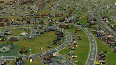
Visualizing Big Data In Your Own SimCity World
Two former Mozilla engineers strive to merge big data with a 3D model of London and, potentially, other cities.
Friday Eye Candy: Revisiting the Sites of Famous Album Covers
For the music aficionados: a recent article in Guardian Cities dug up the Google Street Views of the exact locations of iconic album covers, laying the album cover over the current condition.
'Urban Experiential Displays' Proposed for Philadelphia’s Center City
An outdoor advertising company has crafted legislation, expected for City Council review, to allow electronic displays at seven locations in Center City.
What Does Citi Bike Data Reveal About New York City?
A website called I Quant NY has produced a string of posts examining recent ridership data released by Citi Bike. The visualizations and maps produced by the site make a good case for the value of open data.
EVs, Carpool Lanes, and Affirmative Action: Where's the Connection?
Call it the factionalization of retribution politics in California. When Asian American Democrats dropped their support for an affirmative action measure for education, African American and Latino Dems responded, and new Volt owners lose.

Trends to Watch in Planetizen’s Top Posts
We post a lot of articles here at Planetizen, and the traffic created by you, our audience, provides valuable feedback about the ideas and places of interest to the planning and urbanism community.
The Secrets to Hubway’s Bikeshare Success
Bikeshare programs have met varied degrees of success in North America. Boston’s Hubway, the result of a public-private partnership, is turning a profit entering its fourth year. What's its secret?
After Distracted Driving Crashes Increase, Texas Amplifies ‘Talk, Text, Crash’
The Texas Department of Transportation is responding to a recent increase in the number crashes caused by distracted driving in the state by increasing the presence of a multi-media campaign aimed at changing behavior.
Latest to Open the Roads to Driverless Cars: Washington D.C.
Following actions by the federal government and a few states, the nation’s capital recently published a set of rules regulating the operation of driverless cars.

Developing the First Well-Being Index for Cities
Santa Monica, California is working to become the first city to develop a first well-being index for its residents. The index will help the city’s government measure and serve citizen happiness.

The Facebook for Neighborhoods
Meet Nextdoor, the social network based on proximity, inspired by the conclusion of Robert Putnam’s Bowling Alone that neighborhood social networks make crime go down and test scores go up.

Top Urban Instagram Feeds
Marta Bausells and the readers of Guardian Cities collaborated to create a list of top Instagram photographers from around the world.
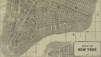
Friday Eye Candy: New York Public Library Releases Thousands of Historic Maps to the Public
“For the historic cartographile, Christmas may have come late, but here it is,” writes Daniel Stuckey.
Charting the 'Urban Shift' Among Technology Start-Ups
Once upon a time, tech start-ups located almost exclusively in the suburbs. New data reveals the extent to which this pattern has been reversed.
Airbnb’s 'Shared City' Program Will Collect, Remit Taxes
Airbnb CEO Brian Chesky recently announced the beginning of the “Shared City” initiative, which will “cut red tape” and “collect and remit taxes.” Airbnb will test the program in Portland before tailoring and exporting the program to other cities.
Legal Battle Over Transportation Network Companies Shifts to Chicago
Chicago political leaders are floating a pair of competing bills that would regulate transportation network companies like Uber, Lyft, and Sidecar. Cab companies are pushing for legislation, seeking a “level playing field” in the market.
Urban Design for Planners 1: Software Tools
This six-course series explores essential urban design concepts using open source software and equips planners with the tools they need to participate fully in the urban design process.
Planning for Universal Design
Learn the tools for implementing Universal Design in planning regulations.
Heyer Gruel & Associates PA
JM Goldson LLC
Custer County Colorado
City of Camden Redevelopment Agency
City of Astoria
Transportation Research & Education Center (TREC) at Portland State University
Camden Redevelopment Agency
City of Claremont
Municipality of Princeton (NJ)


