


Data
Radar Speed Sign 2.0: How a Small Town Calmed Its Traffic
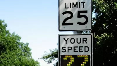
To get a handle on drivers whizzing through its main road, the small town of Betterton, Maryland installed a "smart" radar speed sign. The data it collected helped the local sheriff's department improve traffic enforcement.

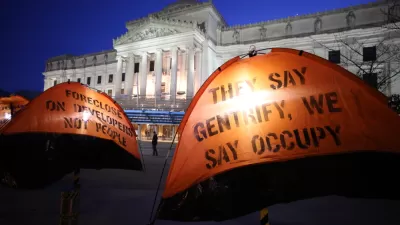
Op-Ed: Time to Ditch the Old Data Used to Separate Gentrification From Displacement
Norman Oder asks readers to question the evidence traditionally cited in arguments that attempt to disprove displacement as a consequence of gentrification.
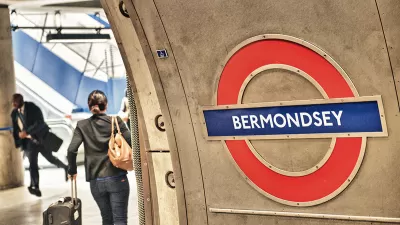
How London's Leading on Transit Data
Transport for London is forging ahead on several projects to collect and use more rider data. One initiative draws on WiFi connections to map users' paths through the London Underground.

The Artist Hubs of America
Data analysis reveals which cities have the most working artists.

Dearth of Data Masks Scale of Distracted Driving Fatalities
Bloomberg links the uptick in traffic fatalities throughout the United States to rising smartphone use while driving.
Mapping the Latest GDP Data for the Nation's Metropolitan Areas
Continuing Planetizen's survey of data dumps by the federal government is a post devoted to the gross domestic product (economic clout, in other words) of the country's metropolitan areas.
How Zillow's Approach to Data Reshaped the Real Estate Market
Zillow's chief analytics officer and chief economist offers insight into the company's approach to data, models, and the real estate market.

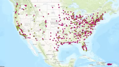
Who's Mapping Gentrification, and Where?
In these cities, data on gentrification has been compiled to build mapping tools documenting the process. The hope is to identify neighborhoods where low-income residents are at risk of displacement.

Internet of Things Brings More Surveillance and Vulnerabilities to Cities
Too often, smart city technology is described as an innocuous tool, but Adam Greenfield argues the technology acquiring this data will be used to distribute city resources, an inherently political act.
The First U.S. 'Noise Map' Could Help Reduce Unsafe Exposure
A new tool from the Department of Transportation maps all the noise created by traffic nationwide.

Trump Administration's Draft Budget Raises New Concerns About Data Collection
President Trump has made no secret of his disdain for many of the traditional data points used to represent the health and prosperity of the country. The budgetary process offers an opportunity to match words with action.

All the Reasons to Map a City's Smells
"Smell-mapping" is gaining attention from urban planners, data scientists, and nature conservationists alike.
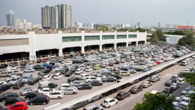
App Detects Open Parking Spaces with 99% Accuracy
Technology startup Parkifi seeks to use the Internet of Things to address the long-lamented problem of congestion created by drivers seeking parking.
Visualizing Gentrification in 9 Cities
A new atlas explores the multiple causes of gentrification through bold graphics and data visualizations.

Is a Universal Metric for Gentrification Possible?
The Guardian’s new "Gentrified World" series tackles a fundamental—but tricky—question: How can we measure gentrification?

Study Opens Doors to Better Eviction Data Nationwide
A survey of renters' housing history in Milwaukee could completely change what we know about eviction in the United States.

Commuting in America 2015
Is commuting Deplorable? Can we Make Commuting Great Again? It is sometimes necessary to resort to hyperbole to draw attention to real data.

A One-Stop Shop for Transportation Data
The Transport Politic has announced the new Transport Databook, with is a kind of treasure trove of data.
Hot Off the Press: The National Transit Map
The U.S. Department of Transit has released its first ever National Transit Map.

Los Angeles' Chief Technology Officer Helped to Connect City on Transit and Transparency
Chief Innovative Technology Officer of Los Angeles, Peter Marx, recently stepped down. But first, he offers some lessons learned during his tenure, which included an L.A. mobility app and a successful open data initiative.
Urban Design for Planners 1: Software Tools
This six-course series explores essential urban design concepts using open source software and equips planners with the tools they need to participate fully in the urban design process.
Planning for Universal Design
Learn the tools for implementing Universal Design in planning regulations.
Smith Gee Studio
City of Charlotte
City of Camden Redevelopment Agency
City of Astoria
Transportation Research & Education Center (TREC) at Portland State University
US High Speed Rail Association
City of Camden Redevelopment Agency
Municipality of Princeton (NJ)


