


The new City Health Dashboard might be the first time many communities have had access to a treasure trove of public health data at the click of a mouse button.

Robin B. Schaz shares news of a new online "City Health Dashboard" that shares and illustrates public health data—both outcomes and drivers—for 500 U.S. cities.
"The City Health Dashboard, developed by NYU Langone Medical Center and the Robert F. Wagner School of Public Service at NYU, features both city- and neighborhood-level data," according to Schaz. Metrics are broken into categories for Social and Economic factors, Physical Environment, Health Behaviors, Health Outcomes, and Clinical Care. In addition to city-level and Census tract data, the platform also includes information on demographic groups.
"The health dashboard originally launched in January as a pilot in Flint, Mich.; Kansas City, Kan.; Providence, R.I.; and Waco, Texas, according to Schaz. "The tool has since expanded nationwide with a $3.4 million grant from the Robert Wood Johnson Foundation."
FULL STORY: New online tool shows how New Yorkers fare on health metrics


Harnessing Data for Community Development
Using data and insights encourages the development of a community, offering an evidence-based strategy to directly address the needs within.
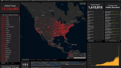
How Mapping Tools Played a Role in Understanding COVID-19
A new episode of the Geospatial Revolution Project assesses how scientists used digital mapping tools to think about the pandemic.

Pandemic Data for Planners
The right data will be critical in crafting effective responses to the threats posed by the coronavirus.

Planetizen Federal Action Tracker
A weekly monitor of how Trump’s orders and actions are impacting planners and planning in America.

San Francisco's School District Spent $105M To Build Affordable Housing for Teachers — And That's Just the Beginning
SFUSD joins a growing list of school districts using their land holdings to address housing affordability challenges faced by their own employees.

The Tiny, Adorable $7,000 Car Turning Japan Onto EVs
The single seat Mibot charges from a regular plug as quickly as an iPad, and is about half the price of an average EV.

San Diego Votes to Rein in “Towering” ADUs
City council voted to limit the number of units in accessory buildings to six — after confronting backyard developments of up to 100 units behind a single family home.

Texas Legislature’s Surprising Pro-Housing Swing
Smaller homes on smaller lots, office to apartment conversions, and 40% less say for NIMBYs, vote state lawmakers.

Even Edmonton Wants Single Staircase Buildings
Canada's second most affordable major city joins those angling to nix the requirement for two staircases in multi-family buildings.
Urban Design for Planners 1: Software Tools
This six-course series explores essential urban design concepts using open source software and equips planners with the tools they need to participate fully in the urban design process.
Planning for Universal Design
Learn the tools for implementing Universal Design in planning regulations.
Borough of Carlisle
Smith Gee Studio
City of Camden Redevelopment Agency
City of Astoria
Transportation Research & Education Center (TREC) at Portland State University
City of Camden Redevelopment Agency
Municipality of Princeton (NJ)