


In car-dependent communities, road diets and bike lanes can be a tough sell.
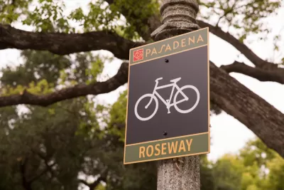
A status quo bias mixed with car dependence can make it hard for communities to eliminate traffic lanes. For a CityLab article, Matt Tinoco shares details of a Pasadena planning meeting, which reviewed a proposal to turn two of four lanes into two lanes: a turn lane and a bike lane. "Shedding lanes, one said, would be an 'unmitigated traffic disaster.' Not only would residents who live along the road never again be able to back out of their driveways, bicycle accidents would increase (because the new lanes would attract more riders)." One official asked for supporters to yell out their support or opposition to the diet, the voices of those opposed were louder. The second hearing on the plan was cancelled in the face of its opposition.
"Such redesigns may be popular with traffic safety advocates—lane reductions have been shown to reduce the total number of crashes by up to 47 percent, according to the Federal Highway Administration," says Tinoco.
Still, anticipated push-back can kill these efforts before they even come to the public. In Los Angeles, officials have been so chastened after the failure of a few road diets (the first of many that had been planned) that they've moved to smaller activations. "Instead of lane reductions, they’re opting for less-aggressive street treatments, like adding signalized crosswalks, dedicated left-turn pockets, and intersection tightening," Tinoco writes
FULL STORY: How to Kill a Bike Lane

Billboard Highlights LA’s Pedestrian Safety Crisis
According to road safety advocates, more pedestrians died on one Los Angeles street than in the entire state of Vermont in 2022.
Safe Streets Funding in Jeopardy
The Trump administration is specifically targeting bike infrastructure and other road safety projects in its funding cuts.
Milwaukee Announces 60 Traffic Calming Projects for 2025
The city has successfully reduced traffic deaths and aims to eliminate them completely within the next decade.

Planetizen Federal Action Tracker
A weekly monitor of how Trump’s orders and actions are impacting planners and planning in America.

Congressman Proposes Bill to Rename DC Metro “Trump Train”
The Make Autorail Great Again Act would withhold federal funding to the system until the Washington Metropolitan Area Transit Authority (WMATA), rebrands as the Washington Metropolitan Authority for Greater Access (WMAGA).

DARTSpace Platform Streamlines Dallas TOD Application Process
The Dallas transit agency hopes a shorter permitting timeline will boost transit-oriented development around rail stations.

San Francisco's School District Spent $105M To Build Affordable Housing for Teachers — And That's Just the Beginning
SFUSD joins a growing list of school districts using their land holdings to address housing affordability challenges faced by their own employees.

Car-Centric LA Suburb Looks to a Train-Oriented Future
City leaders in Rancho Cucamonga, the future western terminus of the Brightline West rail line to Las Vegas, want to reimagine the city as a transit-oriented, pedestrian-friendly community.

New Alaska Bitcoin Mine Would Burn as Much Energy as the State’s Largest Coal Plant
Fueled by “stranded” natural gas, the startup hopes to become the largest in the US, and to make Alaska an industry center.
Urban Design for Planners 1: Software Tools
This six-course series explores essential urban design concepts using open source software and equips planners with the tools they need to participate fully in the urban design process.
Planning for Universal Design
Learn the tools for implementing Universal Design in planning regulations.
Municipality of Princeton
Roanoke Valley-Alleghany Regional Commission
City of Mt Shasta
City of Camden Redevelopment Agency
City of Astoria
Transportation Research & Education Center (TREC) at Portland State University
US High Speed Rail Association
City of Camden Redevelopment Agency
Municipality of Princeton (NJ)