


Los Altos, California has erected a new roadblock in its ongoing effort to keep drivers from cutting through residential neighborhoods, beckoned by the popular navigation app Waze.
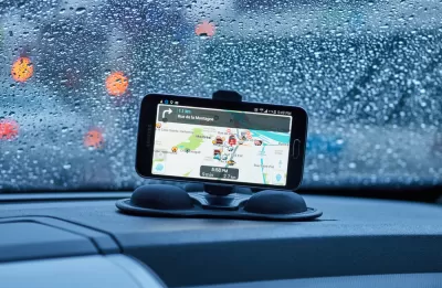
Henry Grabar revisits the continuing story of residential neighborhoods looking for ways to prevent cut-through traffic directed by the popular Waze app. This time the controversy has visited Los Altos, California, where congestion has spilled off of Interstate 280 onto local access roads.
First, Los Altos Hills asked Waze to remove three roads from its map. Waze does not entertain such requests. So Los Alto Hills came up with a Plan B: Close the streets to people who don’t live there. In May, the city erected “No Thru Traffic” signs on three roads where they crossed the city limit. Waze complied, according to a report from the Los Altos Hills manager, which means it will no longer direct users to drive on those streets.
City officials in Georgia, Alabama, and Maryland have nixed the idea in the past, according to Grabar—some citing the questionable legal and enforcement status of such signs. Even in Los Altos, the signs are in a trial period and the city isn't pursuing violators.
FULL STORY: Suburbs Finally Figured Out a Way to Get Rid of Pesky Drivers on Waze Shortcuts

Waze vs. Residential Neighborhoods
Accounts of disgruntled residents responding by any means necessary to the flood of cars beckoned by the whims of navigation apps like Waze are spreading across the country.
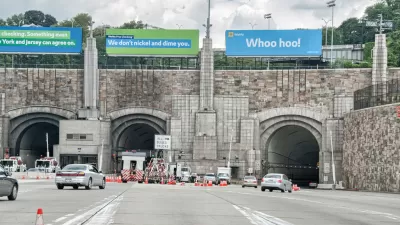
Waze Outfits NYC Tunnels with Beacons for Underground Navigation
The tech is part of a public-private partnership meant to improve connectivity to Waze and other navigation apps from underground.
Flooded With Navigation App Users, a Town Closes Its Streets
Navigation apps like Waze often reroute drivers onto residential streets that would be quiet otherwise. With some residents unable to leave their driveways, the New Jersey borough of Leonia has taken an extreme measure against the problem.

Planetizen Federal Action Tracker
A weekly monitor of how Trump’s orders and actions are impacting planners and planning in America.

Maui's Vacation Rental Debate Turns Ugly
Verbal attacks, misinformation campaigns and fistfights plague a high-stakes debate to convert thousands of vacation rentals into long-term housing.

San Francisco Suspends Traffic Calming Amidst Record Deaths
Citing “a challenging fiscal landscape,” the city will cease the program on the heels of 42 traffic deaths, including 24 pedestrians.

Defunct Pittsburgh Power Plant to Become Residential Tower
A decommissioned steam heat plant will be redeveloped into almost 100 affordable housing units.

Trump Prompts Restructuring of Transportation Research Board in “Unprecedented Overreach”
The TRB has eliminated more than half of its committees including those focused on climate, equity, and cities.

Amtrak Rolls Out New Orleans to Alabama “Mardi Gras” Train
The new service will operate morning and evening departures between Mobile and New Orleans.
Urban Design for Planners 1: Software Tools
This six-course series explores essential urban design concepts using open source software and equips planners with the tools they need to participate fully in the urban design process.
Planning for Universal Design
Learn the tools for implementing Universal Design in planning regulations.
Heyer Gruel & Associates PA
JM Goldson LLC
Custer County Colorado
City of Camden Redevelopment Agency
City of Astoria
Transportation Research & Education Center (TREC) at Portland State University
Jefferson Parish Government
Camden Redevelopment Agency
City of Claremont