


Fans of transit maps will have to watch out for the new map of BaltimoreLink.
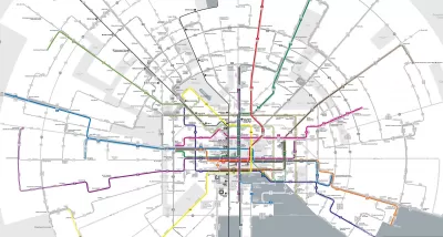
"Baltimore will soon be the latest American city to overhaul its bus network in an attempt to jumpstart ridership," reports Peter Dovak. "The plan, known as 'BaltimoreLink'," will go into effect on June 18. So far the best part is a really, really cool new map."
The Baltimore bus system reorganization follows the famous example of Houston, which reorganized its bus syetm in 2015 and is now one of the few systems in the country attracting on increased numbers of riders in recent years.
"The core of the BaltimoreLink plan is a dozen color-coded, high-frequency routes known as CityLink lines," explains Dovak. "They'll run 24 hours a day along Baltimore's downtown grid and then radiate out of the city in every direction, complimented by less frequent local and express lines."
A good portion of the article is devoted to the design of the Baltimore Link map, which a radial structure that allows for both a striking appearance and legible detail. A quick mention of the system re-structure's political origins—as a replacement for the aborted Red Line Subway project—is also included in the article.

FULL STORY: The map for Baltimore’s new bus system is positively radiant

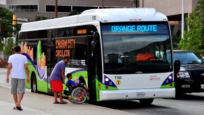
One-Year Later: Evaluating Baltimore's Overhauled Bus System
The $135 million BaltimoreLink bus system redesign launched in June 2017.
Bus System Redesign Coming to the Cleveland Region
The Greater Cleveland Regional Transit Authority (RTA) revealed a draft system redesign this week.
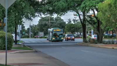
Bus System Redesign Boosts Ridership in Austin
Over a year after Capital Metro in Austin overhauled its bus system design, the system is bucking national trends and achieving growth in its ridership numbers.

Planetizen Federal Action Tracker
A weekly monitor of how Trump’s orders and actions are impacting planners and planning in America.

Congressman Proposes Bill to Rename DC Metro “Trump Train”
The Make Autorail Great Again Act would withhold federal funding to the system until the Washington Metropolitan Area Transit Authority (WMATA), rebrands as the Washington Metropolitan Authority for Greater Access (WMAGA).

The Simple Legislative Tool Transforming Vacant Downtowns
In California, Michigan and Georgia, an easy win is bringing dollars — and delight — back to city centers.

The States Losing Rural Delivery Rooms at an Alarming Pace
In some states, as few as 9% of rural hospitals still deliver babies. As a result, rising pre-term births, no adequate pre-term care and "harrowing" close calls are a growing reality.

The Small South Asian Republic Going all in on EVs
Thanks to one simple policy change less than five years ago, 65% of new cars in this Himalayan country are now electric.

DC Backpedals on Bike Lane Protection, Swaps Barriers for Paint
Citing aesthetic concerns, the city is removing the concrete barriers and flexposts that once separated Arizona Avenue cyclists from motor vehicles.
Urban Design for Planners 1: Software Tools
This six-course series explores essential urban design concepts using open source software and equips planners with the tools they need to participate fully in the urban design process.
Planning for Universal Design
Learn the tools for implementing Universal Design in planning regulations.
Smith Gee Studio
City of Charlotte
City of Camden Redevelopment Agency
City of Astoria
Transportation Research & Education Center (TREC) at Portland State University
US High Speed Rail Association
City of Camden Redevelopment Agency
Municipality of Princeton (NJ)