


An article and video by Chicago PBS station WTTW explore San Francisco's uniquely ambitious approach to sharing the city with wildlife.
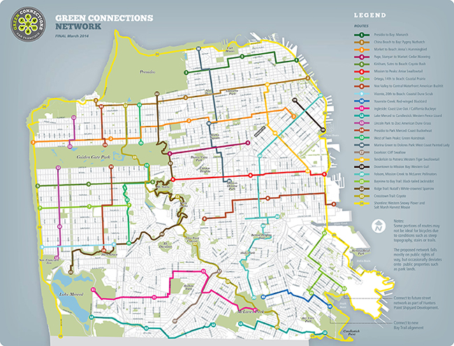
Sean Keenehan reports on San Francisco's Green Connections Plan: "an ambitious 115-mile, 24-route map of potential habitat corridors in San Francisco."
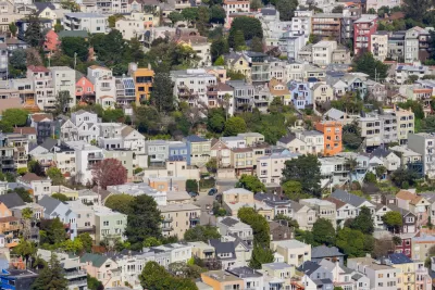
The Green Connections Plan began in 2011, led by the non-profit organization Nature in the City in collaboration with city and community-based agencies. The big idea expands on what we traditionally think about transportation planning by "imagining a world in which cars share the road with birds, bees, butterflies, and bicyclists," explains Keenehan.
"Each route in the network is named after a native San Francisco 'Key Species' and is designed to incorporate 'Key Habitat' for that species," according to Keenehan.
To get a feel for the plan's Green Connections, Keenehan takes a bike ride along with Green Connections director Amber Hasselbring in a video you can watch after the jump.
Local coverage of a recent Green Connections walk is also available on the San Francisco Examiner website.
FULL STORY: A Wild Plan for San Francisco

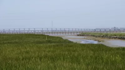
A New Plan for Sea Level Rise in the San Francisco Bay Area
The San Francisco Bay has 400 miles of shoreline, and a dire need for a new approach to dealing with the effects of rising water levels. An estimated $100 billion in potential property damage is at risk.
Adapting Combined Sewer-Stormwater Systems to Climate Change
Only one coastal city has a sewer system that must handle stormwater as well as wastewater. San Francisco's efforts to adapt its combined sewer-stormwater system has put it on the vanguard of the city's climate adaptation efforts.
8 Ways to Sustainably Manage Stormwater
From permeable paving to green roofs, a number of cost-effective and sustainable strategies have emerged for managing water closer to where it falls, rather than directing it into pipes. SPUR explains 8 promising tools for managing stormwater.

Maui's Vacation Rental Debate Turns Ugly
Verbal attacks, misinformation campaigns and fistfights plague a high-stakes debate to convert thousands of vacation rentals into long-term housing.

Planetizen Federal Action Tracker
A weekly monitor of how Trump’s orders and actions are impacting planners and planning in America.

In Urban Planning, AI Prompting Could be the New Design Thinking
Creativity has long been key to great urban design. What if we see AI as our new creative partner?

King County Supportive Housing Program Offers Hope for Unhoused Residents
The county is taking a ‘Housing First’ approach that prioritizes getting people into housing, then offering wraparound supportive services.

Researchers Use AI to Get Clearer Picture of US Housing
Analysts are using artificial intelligence to supercharge their research by allowing them to comb through data faster. Though these AI tools can be error prone, they save time and housing researchers are optimistic about the future.

Making Shared Micromobility More Inclusive
Cities and shared mobility system operators can do more to include people with disabilities in planning and operations, per a new report.
Urban Design for Planners 1: Software Tools
This six-course series explores essential urban design concepts using open source software and equips planners with the tools they need to participate fully in the urban design process.
Planning for Universal Design
Learn the tools for implementing Universal Design in planning regulations.
planning NEXT
Appalachian Highlands Housing Partners
Mpact (founded as Rail~Volution)
City of Camden Redevelopment Agency
City of Astoria
City of Portland
City of Laramie