


A new study uses night sky satellite images to measure urban development patterns in India. The results can help guide smarter growth.

A few years ago I was commissioned by the World Resources Institute to develop a framework for measuring the costs of sprawl and, therefore, the benefits of more efficient development patterns. It was an interesting and challenging project. Using U.S. data, we calculated how various costs (public infrastructure and service delivery, household transportation expenses, traffic deaths, sedentary living, etc.) increase in more dispersed, automobile-dependent cities. The results were published in the report "Analysis of Public Policies That Unintentionally Encourage and Subsidize Urban Sprawl," and discussed in my Planetizen column, Public Policies For Optimal Urban Development.
 Last year WRI asked me to help develop a similar costing framework for India, the preliminary results of which were recently published in the report, "Better Cities, Better Growth: India’s Urban Opportunity."
This was a challenging project due to data limitations. Fortunately, very smart researchers at the Indian Council for Research on International Economic Relations found a solution: they used satellite data night-time light intensity to measure economic activity at a high level of geographical detail, in order to better understand the relationship between urbanization and economic development.
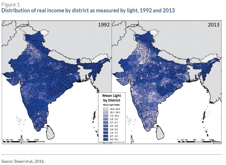
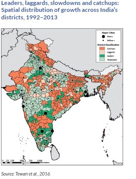
The researchers were able to measure how Indian cities grew in size and economic activity between 1992 and 2013. This information was used to categorize urban districts into "leaders," "laggards," "catchups," and "slowdowns" based on their relative growth rates during this period.
 The researchers found robust evidence that more compact Indian cities have better economic performance than more sprawled cities. The analysis shows that, controlling for differences in initial size and level of development, Indian cities that were initially more compact (i.e., less sprawling) experienced faster economic growth. On average across the sample of 479 Indian cities, a 10 percent increase in a city's dispersion index in 2002 is associated with a 0.4-0.9 percent point decrease in economic growth over the subsequent period. When compounded over time, this difference is significant. Using another measure of urban sprawl, the work demonstrated that growth in economic activity was higher where this took place primarily within existing urban boundaries rather than in expanding urban boundaries. They found that—on average—a 10 percent increase in the growth of existing urban areas relative to newly urbanizing areas (i.e., more compact, intensive urban expansion) is associated with a 0.4-0.5 percent increase in subsequent economic activity. Other measures of compactness returned similar results. This suggests that more compact urbanization, when it occurs, indeed supports faster economic growth.
The analysis indicates that, compared to other large economies such as China and the United States, India's urbanization is underperforming, suggesting that better public policies are needed to allow Indian cities to achieve their economic potential.
We used this information on urban growth patterns to model how sprawled development would likely increase future costs, and therefore the potential savings and benefits from more resource-efficient development patterns. Specifically, we examined how inefficient urban development could increase:
• Costs for providing public infrastructure and services
• Road and parking facility costs
• Transportation costs, particularly for lower-income households
• Per capita traffic casualties and associated damages
• Sedentary living and obesity, leading to increased health problems and lost productivity costs
• More traffic congestion and longer commute times, leading to more air pollution
• Ability of poor households to access basic services and economic opportunities
• Urban agglomeration effects, leading to reduced economic productivity, employment, business activity, investments, and tax revenues
• Open space, leading to reduced agricultural productivity and environmental benefits.
We estimate that sprawled development would increase these costs up to US$1.8 trillion per annum by 2050, or around 6 percent of GDP. These are lower bound underestimates because we did not monetize (measure in monetary units) some significant costs such as agglomeration efficiencies or displaced open space. Described differently, smart growth policies that create more compact and multi-modal communities could be an economic opportunity for India worth more than 6 percent of GDP by mid-century, with significant savings at the household level. Not all of these savings and benefits would be financial, some involve valuable non-market goods such as improved fitness, health, and environmental quality, but the total benefits are significant and particularly helpful to people who are physically, economically, and socially disadvantaged, and so tend to rely on affordable travel modes such as walking, cycling, and public transport.
India's urban development problems are very different than those in North America. Indian cities are very dense, many have more than 50 residents per acre, and very crowded, with less than 30 square feet per interior space per capita, compared with 140 in China. There is tremendous demand for urban housing, but inflexible regulations limit infill in most cities, forcing development to occur in nearby jurisdictions with more flexible regulations, often many miles away from existing jobs and services. Such leapfrog development greatly increases the costs of providing basic services, such as water and power, and leads to automobile dependency.
This illustrates a key issue: smart growth is not primarily concerned with density. It is possible to have dense sprawl (such as highrise developments in automobile-dependent areas) and smart dispersed development (such as walkable rural villages that contain commonly-needed services and good public transit connections to nearby communities).
Sprawled development is particularly harmful to poor households, who bear significantly increased time, money and health costs if they must travel longer distances to reach services and jobs, and bear additional risk when they walk and bicycle, and harm from air pollution caused by more and faster motor vehicle traffic.
Policy reforms can significantly reduce many of these costs, providing economic, social and environmental benefits. The study estimates that policies that create more compact and multi-modal communities can provide savings and benefits equivalent to a 20 percent increase in incomes. The study identified current policies and institutional conditions in India that create cramped housing and encourage costly sprawl over more efficient compact infill development, such as inefficient land registry systems and complex urban planning regulations, and overly restrictive Floor Area Ratios (FAR) that prohibit infill and promote low density development, even in urban cores where there is high demand. In addition, Indian cities have very poor walking and cycling conditions, and have under-invested in public transport, particularly Bus Rapid Transit. Various Transportation Demand Management strategies have been proposed but few have been implemented in Indian cities.
This is important and exciting research: it shines a light on the numerous benefits of more compact, multi-modal urban development. I would like to thank my colleagues at the World Resources Institute and our Indian partners for their excellent work. Well done!
For more information see:
Meenu Tewari, Nick Godfrey, et al. (2016), Better Cities, Better Growth: India’s Urban Opportunity. New Climate Economy, World Resources Institute, and Indian Council for Research on International Economic Relations. Available at: http://newclimateeconomy.report/workingpapers.
Todd Litman (2014), Analysis of Public Policies That Unintentionally Encourage and Subsidize Urban Sprawl, Victoria Transport Policy Institute, commissioned by LSE Cities, for the New Climate Economy Program.
Todd Litman (2015), Response to "Putting People First: An Alternative Perspective with an Evaluation of the NCE Cities 'Trillion Dollar' Report", Victoria Transport Policy Institute.


Study: Sprawl Costs the U.S. Economy $1 Trillion Annually
A major new study estimates that sprawl costs the U.S. economy more than a trillion dollars annually, and results, in part, from planning and market distortions. Smart policy reforms can result in more efficient and equitable development.

A Better Understanding of Smart Growth Benefits
Smart Growth creates compact, multimodal communities where residents consume less land, drive less, and rely more on non-auto modes. Planners have important stories to tell about the benefits of Smart Growth.
A New Guide to Revitalizing Cities Around the World
A major study by the Harvard University Graduate School of Design, "Revitalizing Places: Improving Housing and Neighborhoods from Block to Metropolis," identifies planning strategies to improve housing and urban development practices.

Planetizen Federal Action Tracker
A weekly monitor of how Trump’s orders and actions are impacting planners and planning in America.

Map: Where Senate Republicans Want to Sell Your Public Lands
For public land advocates, the Senate Republicans’ proposal to sell millions of acres of public land in the West is “the biggest fight of their careers.”

Restaurant Patios Were a Pandemic Win — Why Were They so Hard to Keep?
Social distancing requirements and changes in travel patterns prompted cities to pilot new uses for street and sidewalk space. Then it got complicated.

Platform Pilsner: Vancouver Transit Agency Releases... a Beer?
TransLink will receive a portion of every sale of the four-pack.

Toronto Weighs Cheaper Transit, Parking Hikes for Major Events
Special event rates would take effect during large festivals, sports games and concerts to ‘discourage driving, manage congestion and free up space for transit.”

Berlin to Consider Car-Free Zone Larger Than Manhattan
The area bound by the 22-mile Ringbahn would still allow 12 uses of a private automobile per year per person, and several other exemptions.
Urban Design for Planners 1: Software Tools
This six-course series explores essential urban design concepts using open source software and equips planners with the tools they need to participate fully in the urban design process.
Planning for Universal Design
Learn the tools for implementing Universal Design in planning regulations.
Heyer Gruel & Associates PA
JM Goldson LLC
Custer County Colorado
City of Camden Redevelopment Agency
City of Astoria
Transportation Research & Education Center (TREC) at Portland State University
Camden Redevelopment Agency
City of Claremont
Municipality of Princeton (NJ)