


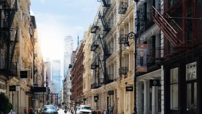
The most dense neighborhood in Manhattan is surprisingly low-key.


When I read the word "hyperdensity," I imagine rows of bland, 90-story towers of the sort one might see in a science fiction movie, or perhaps in certain parts of Hong Kong. But one of America's most dense neighborhoods does not fit this stereotype.
According to the Center for Neighborhood Technology's Housing and Transportation Index, Manhattan’s most dense block group is in the Tudor City neighborhood, just south of 42nd Street and near the East River. This block has 464 dwelling units per square mile—far above the 100-200 units per acre that Jane Jacobs suggested was exemplary, or the 50 or 60 units per acre that other smart growth supporters idealize. So when I visited New York to hunt for apartments, I, of course, had to visit this block.
Tudor City shows that "hyperdense" doesn’t have to mean skyscrapers or luxurious towers. For one thing, Tudor City buildings are only 20-30 stories: not exactly walk-ups, but not extremely tall by New York standards. Buildings taller than Tudor City may actually be less dense; the most luxurious buildings might have more floors, but fewer housing units on each floor.
Another common stereotype is that density means great wealth (in luxurious high-rises) or great poverty (in public housing). But Tudor City has neither. Tudor City’s median household income is just over $90,000—above the Manhattan average, but hardly one of the richest areas in the city. (In fact, Manhattan has several block groups where the median income exceeds $250,000.)
Moreover, Tudor City's rents are actually lower than in most of midtown. I could have found a studio in Tudor City for under $2000, a extremely low figure by the standards of Manhattan doorman buildings (and, I suspect, below average even for walk-ups). Thus, Tudor City explodes the common equation of high density with high rents.
Another common stereotype is that high density means modernist sterility. But Tudor City has retail on the lower floors of some buildings, a generous selection of street trees, and a small park on Tudor City Place (the neighborhood's main street). I'm not quite sure what "human scale" means. But by the standards of midtown Manhattan, Tudor City feels more human scale than I expected. (But don't just take my word for it—look up 25 Tudor City Place on Google Street View.)


Opinion: One Solution to Manhattan's Land Shortage: Just Build It
A New York Times op-ed calls on the city to add landfill development on Manhattan's southern shoreline, claiming it would increase affordability and protect the city from rising sea levels.
Too Much Commercial Zoning for Affordable Housing in SoHo's Controversial Rezoning Plan?
Mayor Bill de Blasio is crossing the finish line of his time in office at the same time as one of the most controversial rezoning processes of his administration.
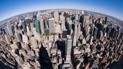
Visualizing Manhattan's Shrinking Density
Although Manhattan has seen in influx of skyscrapers since 1910, overall residential density has shrunk since then.

Planetizen Federal Action Tracker
A weekly monitor of how Trump’s orders and actions are impacting planners and planning in America.

San Francisco's School District Spent $105M To Build Affordable Housing for Teachers — And That's Just the Beginning
SFUSD joins a growing list of school districts using their land holdings to address housing affordability challenges faced by their own employees.

The Tiny, Adorable $7,000 Car Turning Japan Onto EVs
The single seat Mibot charges from a regular plug as quickly as an iPad, and is about half the price of an average EV.

Seattle's Plan for Adopting Driverless Cars
Equity, safety, accessibility and affordability are front of mind as the city prepares for robotaxis and other autonomous vehicles.

As Trump Phases Out FEMA, Is It Time to Flee the Floodplains?
With less federal funding available for disaster relief efforts, the need to relocate at-risk communities is more urgent than ever.

With Protected Lanes, 460% More People Commute by Bike
For those needing more ammo, more data proving what we already knew is here.
Urban Design for Planners 1: Software Tools
This six-course series explores essential urban design concepts using open source software and equips planners with the tools they need to participate fully in the urban design process.
Planning for Universal Design
Learn the tools for implementing Universal Design in planning regulations.
Smith Gee Studio
City of Charlotte
City of Camden Redevelopment Agency
City of Astoria
Transportation Research & Education Center (TREC) at Portland State University
US High Speed Rail Association
City of Camden Redevelopment Agency
Municipality of Princeton (NJ)