


While a federally-funded network of bike paths is in the works elsewhere in the city, the Major Taylor Trail gets little use from Chicago residents. The main problems are a lack of awareness and the South Side's fearsome reputation.
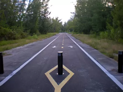
Many Chicago bike enthusiasts frequent the 606, a popular path following an old railroad bed on the Northwest Side. But to the south, the Major Taylor Trail gets little love, though it was built eight years earlier. Mary Wisniewski discusses why that is.
In many respects, Chicagoan cyclists enjoy a widening array of options. One of them is the Cal-Sag trail and the adjacent 86-mile Southland Century bike loop. "The Major Taylor will link to the popular Cal-Sag Trail, being built with $21 million of mostly federal funds. [...] If all goes as planned, in 2018 the Cal-Sag will be the northern leg of a mostly off-road loop that will include the Old Plank Road, Thorn Creek, Centennial and I&M Canal trails and the Burnham and Pennsy greenways."
The biggest drawback for the Major Taylor is crime, or the perception of it. Snaking through low-slung less well-off suburbs of color, the Major Taylor Trail feels deserted. "The trail's solitude adds to the feeling of insecurity: The southern end leading to the Little Calumet River is lovely but on a quiet weekday feels like Fangorn Forest in 'The Lord of the Rings' — vaguely unsettling."
More users means a safer trail, but users won't show up until they think the trail's safe. A catch-22. Meanwhile, "Supporters keep publicizing the trail through the bike community, social media and holding group events to get more people to try it."
FULL STORY: Why the Major Taylor isn't as well-known — or used — as The 606


Advocates Champion the Great Western Trail
A Chicago walking and biking trail along a former railroad right-of-way has been a labor of love for local residents.
Indy Neighborhood Group Builds Temporary Multi-Use Path
Community members, aided in part by funding from the city, repurposed a vehicle lane to create a protected bike and pedestrian path for the summer season.

Washington State Plans Ambitious ‘Cycle Highway’ Network
The state is directing funding to close gaps in its existing bike network and make long-distance trips more accessible.

Planetizen Federal Action Tracker
A weekly monitor of how Trump’s orders and actions are impacting planners and planning in America.

Maui's Vacation Rental Debate Turns Ugly
Verbal attacks, misinformation campaigns and fistfights plague a high-stakes debate to convert thousands of vacation rentals into long-term housing.

Restaurant Patios Were a Pandemic Win — Why Were They so Hard to Keep?
Social distancing requirements and changes in travel patterns prompted cities to pilot new uses for street and sidewalk space. Then it got complicated.

In California Battle of Housing vs. Environment, Housing Just Won
A new state law significantly limits the power of CEQA, an environmental review law that served as a powerful tool for blocking new development.

Boulder Eliminates Parking Minimums Citywide
Officials estimate the cost of building a single underground parking space at up to $100,000.

Orange County, Florida Adopts Largest US “Sprawl Repair” Code
The ‘Orange Code’ seeks to rectify decades of sprawl-inducing, car-oriented development.
Urban Design for Planners 1: Software Tools
This six-course series explores essential urban design concepts using open source software and equips planners with the tools they need to participate fully in the urban design process.
Planning for Universal Design
Learn the tools for implementing Universal Design in planning regulations.
Heyer Gruel & Associates PA
JM Goldson LLC
Custer County Colorado
City of Camden Redevelopment Agency
City of Astoria
Transportation Research & Education Center (TREC) at Portland State University
Jefferson Parish Government
Camden Redevelopment Agency
City of Claremont