


The Federal Highway Administration (FHWA) made official a set of rule changes that overthrow an old way of thinking about street design.
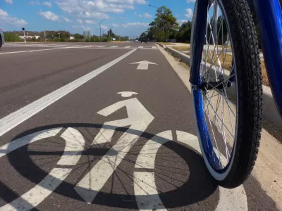
"We probably haven’t seen the last of engineers who insist on designing local streets like surface highways. But at least now they can’t claim their hands are tied by federal regulations," according to an article by Angie Schmitt. That conclusion follows an action by the Federal Highway Administration to remove 11 or 13 existing design rules for national highways, which Schmitt defines as "a 230,000-mile network of roads that includes many urban streets."
Here, Schmitt summarizes the effect of the rule changes:
The rule change eliminates a major obstacle to safe street design around the country. The old rules applied highways design standards — wide lanes, no trees — to streets that function more like main streets, with terrible consequences for safety and walkability.
Schmitt reported on the first hints that the FHWA would change the design rules back in October, but the latest news means the changes are official. May seems to be a productive month for the FHWA, which announced the release of a design guide for separated bike lanes almost exactly a year ago, in May of 2015.
FULL STORY: It Just Got Easier for Cities to Design Walkable, Bikeable Streets

Feds May Drop 'Highway-Inspired' Rules for Streets
The Federal Highway Administration may put an end to rules mandating wide lanes and "clear zones," making it easier to implement complete streets.

Austin Suburb Launches Walkability Study
Kyle, Texas is developing a Sidewalks Master Plan to improve walking facilities.

Houston Developers Question Mayor’s Stance on Pedestrian Projects
The new mayor’s reversal of road safety projects, some already underway or completed, is raising eyebrows among developers who say residents want walkable, mixed-use streets.

Montreal Mall to Become 6,000 Housing Units
Place Versailles will be transformed into a mixed-use complex over the next 25 years.

Planetizen Federal Action Tracker
A weekly monitor of how Trump’s orders and actions are impacting planners and planning in America.

DARTSpace Platform Streamlines Dallas TOD Application Process
The Dallas transit agency hopes a shorter permitting timeline will boost transit-oriented development around rail stations.

Without International Immigrants, the Rural US Population Would Be Falling 58%
Census data shows that population growth in rural areas is due in large part to international migrants.

Dead End: Nine Highways Ready for Retirement
The Freeways Without Futures report describes the nation’s most promising highway removal proposals.

Congressman Proposes Bill to Rename DC Metro “Trump Train”
The Make Autorail Great Again Act would withhold federal funding to the system until the Washington Metropolitan Area Transit Authority (WMATA), rebrands as the Washington Metropolitan Authority for Greater Access (WMAGA).
Urban Design for Planners 1: Software Tools
This six-course series explores essential urban design concepts using open source software and equips planners with the tools they need to participate fully in the urban design process.
Planning for Universal Design
Learn the tools for implementing Universal Design in planning regulations.
City of Mt Shasta
City of Camden Redevelopment Agency
City of Astoria
Transportation Research & Education Center (TREC) at Portland State University
City of Camden Redevelopment Agency
Municipality of Princeton (NJ)
Regional Transportation Commission of Southern Nevada