


The findings of a new study based in Boston offer evidence of negative health outcomes connected to the collision of residential land use and transportation infrastructure.
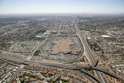
David Abel reports: "A new study of Boston residents who live or spend a significant amount of time near Interstate 93 and the Massachusetts Turnpike has found that their exposure to microscopic metals and chemicals spewed from vehicles increases their chances of suffering a heart attack or stroke."
According to Abel, the study is just the latest addition to a "growing body of evidence of the dangers of living near highways and other busy roads." Specifically, "those who live within 1,500 feet of a highway have a greater likelihood of developing cardiovascular disease than those living twice as far away."
The study was published last week in the Environment International journal, by researchers from the Tufts University School of Medicine and Boston University School of Public Health. The article also includes reactions to the study's findings from the city's Environment Department and local activists like the Chinese Progressive Association in Chinatown.
FULL STORY: New evidence of the dangers of living near highways

24 States Sue EPA Over New Soot Pollution Limit
The agency cites health risks of air pollution as reason for the new limit; states appear concerned it will kill their economies.

Deep Economic and Racial Injustice Found in California Pollution Exposure
A new study confirms the facts of environment justice that has long been common knowledge in affected communities. Now the evidence can be mapped, as well.

'Affordable Clean Energy Rule' Proposed to Replace Clean Power Plan
On Tuesday, EPA released its new rule to regulate emissions from existing power plants, essentially leaving it to the states to determine appropriate emissions levels rather than setting actual standards each state has to meet like the current rule.

Montreal Mall to Become 6,000 Housing Units
Place Versailles will be transformed into a mixed-use complex over the next 25 years.

Planetizen Federal Action Tracker
A weekly monitor of how Trump’s orders and actions are impacting planners and planning in America.

DARTSpace Platform Streamlines Dallas TOD Application Process
The Dallas transit agency hopes a shorter permitting timeline will boost transit-oriented development around rail stations.

Interactive Map Reveals America's “Shade Deserts”
Launched by UCLA and American Forests to combat heat-related deaths, the tool maps the shade infrastructure for over 360 U.S. cities.

Bicycles and Books — In Sacramento, Libraries Now Offer Both
Adult library card holders can check out e-bikes and e-trikes for up to one week.

Colorado Landfills Emit as Much Pollution as 1M Cars
Landfills are the third-largest source of methane pollution in Colorado, after agriculture and fossil fuel extraction.
Urban Design for Planners 1: Software Tools
This six-course series explores essential urban design concepts using open source software and equips planners with the tools they need to participate fully in the urban design process.
Planning for Universal Design
Learn the tools for implementing Universal Design in planning regulations.
City of Mt Shasta
City of Camden Redevelopment Agency
City of Astoria
Transportation Research & Education Center (TREC) at Portland State University
US High Speed Rail Association
City of Camden Redevelopment Agency
Municipality of Princeton (NJ)