


Rockville, Maryland has plans to create a king-sized complete street along Rockville Pike, incorporating lanes for cars, bikes, buses, and more space for landscaping. But can a street like that still serve pedestrians?
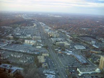
Rockville Pike is a high-traffic thoroughfare and a prime candidate for complete streets upgrades. But Dan Malouff sees trouble in the city's current plan to build a mega-complete street with "12 car lanes, 4 bike lanes, 2 bus lanes, and over 50 feet of landscaping."
From the article: "At first glance, this plan has all the components of a good complete street design: Tree-lined sidwalks, protected bikeways, a center-running dedicated busway. Every mode gets all the street width it could possibly want." Except, Malouff argues, the very pedestrians complete streets are supposed to prioritize.
By over-delivering on the accessories to walkability, the Rockville Pike plan may undermine its original intent. "Transit oriented development doesn't work unless it's walkable. If Rockville Pike is too wide, development on one side of the street will be effectively cut-off from development on the other side. Riders won't be able to easily access the BRT stations. People will drive for even short trips. The concept of a community where people don't need to drive everywhere will break down."
FULL STORY: Rockville misses the forest for the trees with its plan for an 18-lane mega main street

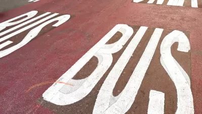
New York DOT Status Report Shows Slow Progress on Bus, Bike Lanes
According to a report released by the agency, NYCDOT failed to meet its benchmarks for installing new dedicated bus and bike lanes.
NYC Streets Plan Remains Largely on Paper
For the second year in a row, the city failed to meet legally required targets for building protected bike lanes and bus lanes.
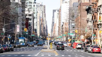
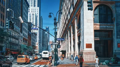
Third Avenue Redesign Plan Revealed
The plan to reimagine Manhattan’s Third Avenue to make it safer for pedestrians and cyclists is being applauded by advocates, but some say the city should go further to provide more space for multimodal transportation.

Montreal Mall to Become 6,000 Housing Units
Place Versailles will be transformed into a mixed-use complex over the next 25 years.

Planetizen Federal Action Tracker
A weekly monitor of how Trump’s orders and actions are impacting planners and planning in America.

Four Reasons Urban Planners Can’t Ignore AI
It’s no longer a question of whether AI will shape planning, but how. That how is up to us.

Bend, Deschutes County Move to Restrict Major Homeless Encampment
City and county officials are closing off portions of an area known as Juniper Ridge where many unhoused residents find shelter, hoping to direct people to housing and supportive services.

High Housing Costs Driving Down Transit Ridership in LA
When neighborhoods gentrify and displace lower-income residents, transit ridership suffers, new research shows.

Iowa Legalizes Accessory Dwelling Units
A new law will allow property owners to build ADUs on single-family lots starting on July 1.
Urban Design for Planners 1: Software Tools
This six-course series explores essential urban design concepts using open source software and equips planners with the tools they need to participate fully in the urban design process.
Planning for Universal Design
Learn the tools for implementing Universal Design in planning regulations.
City of Mt Shasta
City of Camden Redevelopment Agency
City of Astoria
Transportation Research & Education Center (TREC) at Portland State University
City of Camden Redevelopment Agency
Municipality of Princeton (NJ)
Regional Transportation Commission of Southern Nevada