


Transportation Secretary Antony Foxx called on local transit agencies earlier this month to share data to be used in building a comprehensive map of the nation's transit lines.
Faiz Siddiqui reports on the goals of the National Transit Map, i.e., "a nationwide effort to cull data from transit agencies into a comprehensive feed for anyone to use."
The initiative launched on March 8, with data collection scheduled to begin on March 31, according to a U.S. Department of Transportation website announcing the project.
According to Siddiqui, the initiative is intended to help pinpoint transit deserts, and "use the information to help persuade policymakers to improve public transportation in underserved communities."
The article includes more of the technical details of the data request, potential applications of the data the U.S. DOT hopes to collect in the process, and more background on the nation's transit deserts and their impacts on economic mobility.
FULL STORY: How a National Transit Map could connect ‘transit deserts’ to the grid

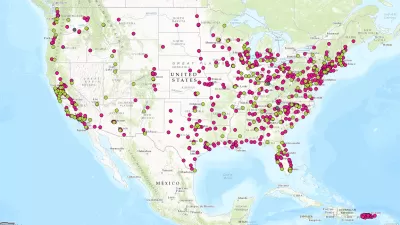
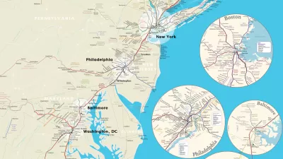
Hot Off the Press: The National Transit Map
The U.S. Department of Transit has released its first ever National Transit Map.
Where USDOT Awarded $3.2 Billion in Grants
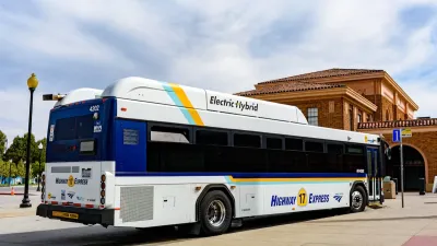
The department announced awards for projects that include intercity rail, low-emission buses, and tech-driven transit improvements.
Beyond Congestion Pricing: Strategies for Revolutionizing Urban Mobility
How cities are leveraging data and technology to improve their transportation networks and reduce traffic.

Planetizen Federal Action Tracker
A weekly monitor of how Trump’s orders and actions are impacting planners and planning in America.

Congressman Proposes Bill to Rename DC Metro “Trump Train”
The Make Autorail Great Again Act would withhold federal funding to the system until the Washington Metropolitan Area Transit Authority (WMATA), rebrands as the Washington Metropolitan Authority for Greater Access (WMAGA).

The Simple Legislative Tool Transforming Vacant Downtowns
In California, Michigan and Georgia, an easy win is bringing dollars — and delight — back to city centers.

The States Losing Rural Delivery Rooms at an Alarming Pace
In some states, as few as 9% of rural hospitals still deliver babies. As a result, rising pre-term births, no adequate pre-term care and "harrowing" close calls are a growing reality.

The Small South Asian Republic Going all in on EVs
Thanks to one simple policy change less than five years ago, 65% of new cars in this Himalayan country are now electric.

DC Backpedals on Bike Lane Protection, Swaps Barriers for Paint
Citing aesthetic concerns, the city is removing the concrete barriers and flexposts that once separated Arizona Avenue cyclists from motor vehicles.
Urban Design for Planners 1: Software Tools
This six-course series explores essential urban design concepts using open source software and equips planners with the tools they need to participate fully in the urban design process.
Planning for Universal Design
Learn the tools for implementing Universal Design in planning regulations.
Smith Gee Studio
City of Charlotte
City of Camden Redevelopment Agency
City of Astoria
Transportation Research & Education Center (TREC) at Portland State University
US High Speed Rail Association
City of Camden Redevelopment Agency
Municipality of Princeton (NJ)