


Suburban retrofit: what's next in issues, approaches, strategies, and tools.
"Local and regional governments in outlying areas are beginning to recognize the advantages of reversing sprawl — and the risks of not acting."
"America has about twelve thousand square miles of land, an area equivalent to the states of Connecticut and New Jersey, that are used for surface parking, loading, storage, and other nonstructural uses. The supply of this land is so vast that nearly all of America’s new nonresidential spaces and nearly all new multilevel attached residential units can easily occur on the parking lots of existing nonresidential development, especially along commercial corridors and in suburban centers."
Ben Brown quotes Lynn Richards, Arthur Nelson, Rob Steuteville, the Urban Land Institute, and Galina Tachieva as he gives us the latest on suburban retrofit and sprawl repair.

An early retrofit of an outmoded suburban mall, Mashpee Commons began its transformation, with DPZ & Co. as design lead, in the late 1980s. It has evolved into a mixed-use core for an emerging town where once there was centerless suburbia. Image Credit: DPZ & Co.
FULL STORY: The Next Frontier for Compact Walkability? It’s gotta be the burbs

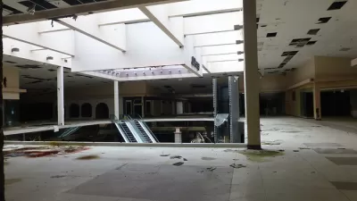
How To: Makeovers for Struggling Malls
Lean Urbanism recently released a "lean" guide to sprawl repair—focusing on how to bring struggling shopping malls back to life.
A Deep Dive into Suburban Retrofits
An interview with Ellen Dunham-Jones, co-author of "Retrofitting Suburbia," and Hazel Borys.

What an Innocuous Piece of Plastic Says About Our Suburban Future
Suburban Starbucks models are bumming urbanists out. But they also served as a nice allegory of what the future there might hold. Scott Doyon's latest blog post explains.

Planetizen Federal Action Tracker
A weekly monitor of how Trump’s orders and actions are impacting planners and planning in America.

Restaurant Patios Were a Pandemic Win — Why Were They so Hard to Keep?
Social distancing requirements and changes in travel patterns prompted cities to pilot new uses for street and sidewalk space. Then it got complicated.

Map: Where Senate Republicans Want to Sell Your Public Lands
For public land advocates, the Senate Republicans’ proposal to sell millions of acres of public land in the West is “the biggest fight of their careers.”

Maui's Vacation Rental Debate Turns Ugly
Verbal attacks, misinformation campaigns and fistfights plague a high-stakes debate to convert thousands of vacation rentals into long-term housing.

San Francisco Suspends Traffic Calming Amidst Record Deaths
Citing “a challenging fiscal landscape,” the city will cease the program on the heels of 42 traffic deaths, including 24 pedestrians.

California Homeless Arrests, Citations Spike After Ruling
An investigation reveals that anti-homeless actions increased up to 500% after Grants Pass v. Johnson — even in cities claiming no policy change.
Urban Design for Planners 1: Software Tools
This six-course series explores essential urban design concepts using open source software and equips planners with the tools they need to participate fully in the urban design process.
Planning for Universal Design
Learn the tools for implementing Universal Design in planning regulations.
Heyer Gruel & Associates PA
JM Goldson LLC
Custer County Colorado
City of Camden Redevelopment Agency
City of Astoria
Transportation Research & Education Center (TREC) at Portland State University
Camden Redevelopment Agency
City of Claremont
Municipality of Princeton (NJ)