


An interview with Ellen Dunham-Jones, co-author of "Retrofitting Suburbia," and Hazel Borys.
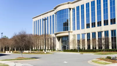
"Q2: You offer up a pithy summary of the US market, noting that of the 1,100 shopping malls, one third are dead or dying. The 50,000 strip malls have a 11% vacancy rate. Within the 350,000 big box stores, 300 million square feet are vacant. However, you point out these dynamics have been around awhile, with the newest marker being the suburban office vacancy rates of 16-24%. What has changed to make these suburban offices less attractive?"
"There are several converging factors here. The one most frequently cited by CEOs is the need to relocate to the cities that are attracting the educated 25-34 year-olds that they most want to hire and who, for the most part, find the idea of working in a Dilbert-like suburban cubicle un-creative and toxic. Additional factors include the fact that computers have automated many of the clerical jobs that used to be done in the suburban back-offices at the same time that space/employee standards have significantly reduced. The wave of ’80′s office parks and corporate campuses are aging and increasingly out of date, while the cities have become immensely more livable than they were in the '70s. So, we're seeing the tide reverse itself as a wave of corporate relocate out of suburbs and back into cities and newly named 'innovation districts.'"
FULL STORY: Suburban Retrofits: A deep dive


What an Innocuous Piece of Plastic Says About Our Suburban Future
Suburban Starbucks models are bumming urbanists out. But they also served as a nice allegory of what the future there might hold. Scott Doyon's latest blog post explains.
Healthy, or Unhealthy, by Design
We've engineered physical activity out of our daily lives but it need not be a chronic condition. Hazel Borys points to recent suburban retrofits for ways to get moving again.
A Summary of CNU24 Detroit
Miss the Congress for the New Urbanism in Detroit? Hazel Borys shares some highlights, with help from Twitter urbanists.

Maui's Vacation Rental Debate Turns Ugly
Verbal attacks, misinformation campaigns and fistfights plague a high-stakes debate to convert thousands of vacation rentals into long-term housing.

Planetizen Federal Action Tracker
A weekly monitor of how Trump’s orders and actions are impacting planners and planning in America.

San Francisco Suspends Traffic Calming Amidst Record Deaths
Citing “a challenging fiscal landscape,” the city will cease the program on the heels of 42 traffic deaths, including 24 pedestrians.

Defunct Pittsburgh Power Plant to Become Residential Tower
A decommissioned steam heat plant will be redeveloped into almost 100 affordable housing units.

Trump Prompts Restructuring of Transportation Research Board in “Unprecedented Overreach”
The TRB has eliminated more than half of its committees including those focused on climate, equity, and cities.

Amtrak Rolls Out New Orleans to Alabama “Mardi Gras” Train
The new service will operate morning and evening departures between Mobile and New Orleans.
Urban Design for Planners 1: Software Tools
This six-course series explores essential urban design concepts using open source software and equips planners with the tools they need to participate fully in the urban design process.
Planning for Universal Design
Learn the tools for implementing Universal Design in planning regulations.
Heyer Gruel & Associates PA
JM Goldson LLC
Custer County Colorado
City of Camden Redevelopment Agency
City of Astoria
Transportation Research & Education Center (TREC) at Portland State University
Jefferson Parish Government
Camden Redevelopment Agency
City of Claremont