


Containing more than 500 open datasets, GeoHub lets users access the wealth of data Los Angeles makes available. The tool is also intended to help employees from different city departments work together.

Early this year, the city of Los Angeles made public a new data visualization tool called GeoHub. Josh Cohen writes, "GeoHub is a searchable directory of over 500 eclectic L.A. city datasets such as farmers markets, emergency services, construction projects, streams and rivers, volunteer opportunities, crime, performing arts centers, and many more."
Catherine Geanuracos, a civic hacker and member of L.A.'s innovation and performance commison, remarked, "'When Mayor Garcetti took office, he started moving forward with open data. This is the next step on that from the city.'" Geanuracos went on, "The city of L.A. has been extremely siloed. Anything that prompts collaboration will be really valuable for the city overall, whether it's planning or evaluation."
L.A.'s deputy chief data officer Lillian Coral hopes GeoHub can be useful to an "engaged citizenry" of journalists, advocates, and others who may lack the time or technical acumen to decipher open data in its raw form.
FULL STORY: L.A. Opens Up More With New Data Tool

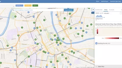
Presenting Municipal Data in an Interactive Map, Nashville Style
The city of Nashville launched the NashView interactive data map earlier this month.

DataUSA: An Intuitive Tool for Public Data
A collaboration between Deloitte, Datawheel, and MIT has produced an intuitive aesthetically-pleasing gathering point for public data in the United States. Specific locations and industries boast easy-to-read profiles.

Mapping the Age of Every Building in Los Angeles
Developed using open data from local government sources, built: LA is a mapping tool that displays the age of every building in the county. Much of the area's built environment is surprisingly old.

Planetizen Federal Action Tracker
A weekly monitor of how Trump’s orders and actions are impacting planners and planning in America.

DARTSpace Platform Streamlines Dallas TOD Application Process
The Dallas transit agency hopes a shorter permitting timeline will boost transit-oriented development around rail stations.

Congressman Proposes Bill to Rename DC Metro “Trump Train”
The Make Autorail Great Again Act would withhold federal funding to the system until the Washington Metropolitan Area Transit Authority (WMATA), rebrands as the Washington Metropolitan Authority for Greater Access (WMAGA).

Supreme Court Ruling in Pipeline Case Guts Federal Environmental Law
The decision limits the scope of a federal law that mandates extensive environmental impact reviews of energy, infrastructure, and transportation projects.

Texas State Bills to Defund Dallas Transit Die
DART would have seen a 30% service cut, $230M annual losses had the bills survived.

Bikeshare for the Win: Team Pedals to London Cricket Match, Beats Rivals Stuck in Traffic
While their opponents sat in gridlock, England's national cricket team hopped Lime bikes, riding to a 3-0 victory.
Urban Design for Planners 1: Software Tools
This six-course series explores essential urban design concepts using open source software and equips planners with the tools they need to participate fully in the urban design process.
Planning for Universal Design
Learn the tools for implementing Universal Design in planning regulations.
Roanoke Valley-Alleghany Regional Commission
City of Mt Shasta
City of Camden Redevelopment Agency
City of Astoria
Transportation Research & Education Center (TREC) at Portland State University
US High Speed Rail Association
City of Camden Redevelopment Agency
Municipality of Princeton (NJ)