


San Diego's downtown, dominated by 3-lane one-way streets engineered to maximize car velocity and traffic flow, may be getting redesigned to make it hospitable for bicyclists and pedestrians.
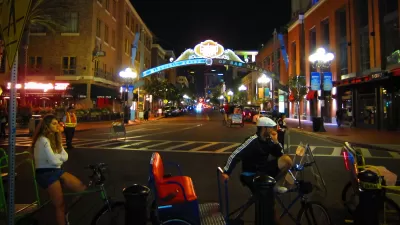
Downtown San Diego's street grid could have made Jane Jacobs proud with its short blocks and multiple cross-streets. Unfortunately, most of that public right of way has been engineered solely for automobile-mobility, with one-way three-lane streets, timed traffic lights, the resultant high speed traffic, parallel parking, and aggressive (and costly) jaywalking enforcement. The auto-oriented street grid leaves little room for cyclists and is inhospitable for walkers, despite the fact that Downtown San Diego's small blocks and concomitant greater number of streets leave ample room to accommodate all modes of mobility.
All that could soon change. The city has issued a draft of the Downtown San Diego Mobility Plan, years in the making, "with a goal of reducing travel by car and increasing trips by bike and foot" writes dedicated downtown urbanist Bill Keller. Among the features contained in the plan,
Perhaps the most ambitious idea is the network of Bike Paths, Lanes, Routes and Cycle Tracks detailed in Chapter 5 Bicycling. For example, a two-way cycle track separated from traffic would run along the west side of Sixth Ave from Beech St down to L St. Cycle tracks are also proposed along sections of Pacific Highway, State St, Park Blvd, Grape St, Hawthorne, Beech, Broadway, C St, and J St.
A public workshop is scheduled for February 23rd and the public review period is open until March 11, 2016. Comments may be submitted at the Mobility Plan website.
FULL STORY: Downtown San Diego Mobility Plan — Draft Released


Planetizen Federal Action Tracker
A weekly monitor of how Trump’s orders and actions are impacting planners and planning in America.

San Francisco's School District Spent $105M To Build Affordable Housing for Teachers — And That's Just the Beginning
SFUSD joins a growing list of school districts using their land holdings to address housing affordability challenges faced by their own employees.

The Tiny, Adorable $7,000 Car Turning Japan Onto EVs
The single seat Mibot charges from a regular plug as quickly as an iPad, and is about half the price of an average EV.

Seattle's Plan for Adopting Driverless Cars
Equity, safety, accessibility and affordability are front of mind as the city prepares for robotaxis and other autonomous vehicles.

As Trump Phases Out FEMA, Is It Time to Flee the Floodplains?
With less federal funding available for disaster relief efforts, the need to relocate at-risk communities is more urgent than ever.

With Protected Lanes, 460% More People Commute by Bike
For those needing more ammo, more data proving what we already knew is here.
Urban Design for Planners 1: Software Tools
This six-course series explores essential urban design concepts using open source software and equips planners with the tools they need to participate fully in the urban design process.
Planning for Universal Design
Learn the tools for implementing Universal Design in planning regulations.
Smith Gee Studio
City of Charlotte
City of Camden Redevelopment Agency
City of Astoria
Transportation Research & Education Center (TREC) at Portland State University
US High Speed Rail Association
City of Camden Redevelopment Agency
Municipality of Princeton (NJ)