


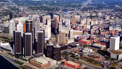
Logically we might assume that as cities grow larger, commutes get harder. It can certainly feel that way. But research points to structural factors that actually make commuting in big cities more efficient.

Traffic can be annoying, but it also suggests that a city is thriving. Eric Jaffe writes, "What is a little surprising is that even as cities get larger, life in them doesn't necessarily grind to a halt. Sure, it can sometimes feel like that's the case when you're stuck in rush-hour gridlock. But while traffic congestion may be a personal annoyance, it's also a broad indication of a healthy economy."
Despite their high populations, commuting in big cities is more efficient than one might think. "The reason bigger workforces don't translate into total stagnation is that metros have 'nimble and self-adjusting commuting patterns' that preserve their economic advantage, report [Shlomo Angel and Alejandro Blei] in a paper in the journal Cities. Those patterns have three key components: density, job and home relocation, and overall mobility."
Jaffe goes on to discuss each of these factors in detail. The implications for planning are mixed: "On one hand, the benefits of density and mobility suggest a need for compact development near transit lines; on the other hand, the benefits of freeway speed would seem to endorse a transportation status quo that centers on car travel."
FULL STORY: Why Commutes Aren't Twice as Long in Cities With Twice the Population


Coupling Housing and Mobility: A Radical Rethink for Freeways
An ambitious vision for freeways: intersections with dense, tall buildings and rights of way repurposed for high-speed, high-capacity public transit.
Most Downtowns Still Lagging Behind
Central districts have been surging back since the 1980s. But in most cities, the upper third of earners still favor outlying areas and are underrepresented closer to downtown.
TTI's Urban Mobility Report Flawed, Says Critic
The Texas Transportation Institute just released its 2010 Urban Mobility Report, which is a standard reference in the road-building industry -- and is seriously flawed, says Joe Cortright.

Maui's Vacation Rental Debate Turns Ugly
Verbal attacks, misinformation campaigns and fistfights plague a high-stakes debate to convert thousands of vacation rentals into long-term housing.

Planetizen Federal Action Tracker
A weekly monitor of how Trump’s orders and actions are impacting planners and planning in America.

In Urban Planning, AI Prompting Could be the New Design Thinking
Creativity has long been key to great urban design. What if we see AI as our new creative partner?

How Trump's HUD Budget Proposal Would Harm Homelessness Response
Experts say the change to the HUD budget would make it more difficult to identify people who are homeless and connect them with services, and to prevent homelessness.

The Vast Potential of the Right-of-Way
One writer argues that the space between two building faces is the most important element of the built environment.

Florida Seniors Face Rising Homelessness Risk
High housing costs are pushing more seniors, many of them on a fixed income, into homelessness.
Urban Design for Planners 1: Software Tools
This six-course series explores essential urban design concepts using open source software and equips planners with the tools they need to participate fully in the urban design process.
Planning for Universal Design
Learn the tools for implementing Universal Design in planning regulations.
Gallatin County Department of Planning & Community Development
Heyer Gruel & Associates PA
JM Goldson LLC
City of Camden Redevelopment Agency
City of Astoria
Transportation Research & Education Center (TREC) at Portland State University
Jefferson Parish Government
Camden Redevelopment Agency
City of Claremont