


The city of Cleveland's first protected bike path has planning commission approval. The protected path is a component of the city's ambitious bike infrastructure plans.
Steven Litt reports that the Cleveland Planning Commission "unanimously approved conceptual plans for the Lorain Avenue Bikeway, modeled after the widely acclaimed Cultural Trail in Indianapolis."
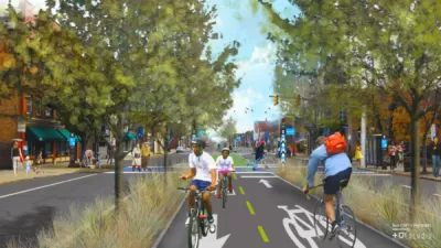
"The $16 million Lorain Avenue project would transform 2.25 miles of the four-lane avenue from West 20th to West 65th Street into a multi-modal route with two lanes for vehicles, a lane for parking and bus stops, and a 10-foot strip separated from traffic for bikes."
If granted final approval, the protected path along Lorain Avenue would further the city's goals of doubling the mileage of city bike paths by 2017. The city also plans to add another 80 miles by 2019, according to Litt. The controversial Opportunity Corridor project also includes plans for a two-mile protected bike path along the route.
Litt notes the argument of complete streets and bike advocates that the city's road infrastructure was built for the larger population of the city in the 20th century, like other cities around the country.
Litt also describes the Cultural Trail in Indianapolis in more detail as an inspiration for the Lorain Avenue Bikeway.
FULL STORY: Lorain Avenue Bikeway concept gets a big boost from Cleveland planning commission (photos)

Two Steps Forward, One Step Back for Cleveland Cycle Track Plans
Advocates are thrilled that the city of Cleveland is seeking federal funding for a pair of ambitious cycle track plans—but one of the plans has been significantly watered down.

Cleveland's First Protected Bike Lanes Get $14 Million Boost
[Updated] The Northeast Ohio Areawide Coordinating Agency will provide the funding for two ambitious protected bike lanes in Cleveland.
Support for a Protected Bike Path Along Cleveland's 'Opportunity Corridor'
The unfolding saga of Cleveland's proposed Opportunity Corridor project has a new twist: community development organizations and bike advocates would like to add a protected bike path alongside the route.

Planetizen Federal Action Tracker
A weekly monitor of how Trump’s orders and actions are impacting planners and planning in America.

Chicago’s Ghost Rails
Just beneath the surface of the modern city lie the remnants of its expansive early 20th-century streetcar system.

San Antonio and Austin are Fusing Into one Massive Megaregion
The region spanning the two central Texas cities is growing fast, posing challenges for local infrastructure and water supplies.

Since Zion's Shuttles Went Electric “The Smog is Gone”
Visitors to Zion National Park can enjoy the canyon via the nation’s first fully electric park shuttle system.

Trump Distributing DOT Safety Funds at 1/10 Rate of Biden
Funds for Safe Streets and other transportation safety and equity programs are being held up by administrative reviews and conflicts with the Trump administration’s priorities.

German Cities Subsidize Taxis for Women Amid Wave of Violence
Free or low-cost taxi rides can help women navigate cities more safely, but critics say the programs don't address the root causes of violence against women.
Urban Design for Planners 1: Software Tools
This six-course series explores essential urban design concepts using open source software and equips planners with the tools they need to participate fully in the urban design process.
Planning for Universal Design
Learn the tools for implementing Universal Design in planning regulations.
planning NEXT
Appalachian Highlands Housing Partners
Mpact (founded as Rail~Volution)
City of Camden Redevelopment Agency
City of Astoria
City of Portland
City of Laramie