


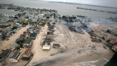
In a worst case scenario, generated by a new study published in the Proceedings of the National Academy of Sciences of the United States of America, land home to 25 million Americans will be lost to rising seas as a result of climate change.
Chris Mooney shares news of a study that details the land on the coast of the United States that will be inundated by sea water as the effects of climate change become more and more cemented into the environment. "Future emissions will determine which areas we can continue to occupy or may have to abandon," according to the report.
Many U.S. cities are "committed to futures below sea level," if climate change continues unchecked. The critical number that drives the study's estimates: "For every one degree Celsius of warming, the scientists estimate that we should expect 2.3 meters of long-term, eventual sea-level rise, playing out over millennia."
Benjamin Strauss of Climate Central in Princeton, N.J. led the study, with co-authors Scott Kulp of Climate Central and Anders Levermann of the Potsdam Institute for Climate Impact Research in Germany.
So according to the study's calculations, if the world were to continue with business as usual and suffer the consequences of the sea level rise that would follow, "the current locations of over 26 million Americans’ homes might be inundated, and more than 1,500 U.S. cities and municipalities could find the areas where half of the residents live inundated." For those doing the quick math at home, that's more people than live in each of 48 states in the United States—all but California and Texas.
Climate Central has an interactive map that shows how the country's geography would change in various scenarios of increased temperatures and corresponding sea levels.
A similar study, released last year, targeted Anchorage, Seattle, and Detroit as prime real estate after the seas come for the country's current coastal communities.
FULL STORY: This is how rising seas will reshape the face of the United States


California State Law Calls on Coastal Regions to Create Resiliency Plans
Cities and counties at risk of flooding and erosion from sea level rise can access state funding to implement coastal resiliency plans.
Coastal City Rejects 'Managed Retreat' Strategy
Del Mar, in Southern California, says it does not want to adopt the approach as part of its sea-level rise adaptation plan.

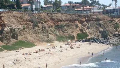
Sea Level Rise Will Not Be Uniform
As the climate warms, the world's glaciers and ice sheets are melting, but sea level increase will be greater in some places due to the earth's rotation and gravity, according to a newly released study by the NASA Jet Propulsion Laboratory.

Planetizen Federal Action Tracker
A weekly monitor of how Trump’s orders and actions are impacting planners and planning in America.

Map: Where Senate Republicans Want to Sell Your Public Lands
For public land advocates, the Senate Republicans’ proposal to sell millions of acres of public land in the West is “the biggest fight of their careers.”

Restaurant Patios Were a Pandemic Win — Why Were They so Hard to Keep?
Social distancing requirements and changes in travel patterns prompted cities to pilot new uses for street and sidewalk space. Then it got complicated.

Platform Pilsner: Vancouver Transit Agency Releases... a Beer?
TransLink will receive a portion of every sale of the four-pack.

Toronto Weighs Cheaper Transit, Parking Hikes for Major Events
Special event rates would take effect during large festivals, sports games and concerts to ‘discourage driving, manage congestion and free up space for transit.”

Berlin to Consider Car-Free Zone Larger Than Manhattan
The area bound by the 22-mile Ringbahn would still allow 12 uses of a private automobile per year per person, and several other exemptions.
Urban Design for Planners 1: Software Tools
This six-course series explores essential urban design concepts using open source software and equips planners with the tools they need to participate fully in the urban design process.
Planning for Universal Design
Learn the tools for implementing Universal Design in planning regulations.
Heyer Gruel & Associates PA
JM Goldson LLC
Custer County Colorado
City of Camden Redevelopment Agency
City of Astoria
Transportation Research & Education Center (TREC) at Portland State University
Camden Redevelopment Agency
City of Claremont
Municipality of Princeton (NJ)