


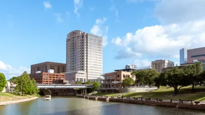
Houston's Pierce Elevated, a section of the I-45 freeway, is the latest target in the movement to remove urban freeways.
"John Norquist, the former mayor of Milwaukee, said the elevated section of I-45 between Houston’s Midtown and Downtown should be eliminated in favor of a surface-level street," reports Ryan Holleywell.
Norquist, of course, is also well known for his leadership at the Congress for New Urbanism, not just the city of Milwaukee.
According to Holleywell, "His comments come at a time when the Texas Department of Transportation is considering moving I-45 east of its current downtown location and eliminating the Pierce Elevated."
The article includes more background on the freeway removal agenda pursued by Norquist and his colleagues. In July, Tory Gattis reported that a proposal to turn the freeway into an elevated park were no longer under consideration. Gail Delaughter reported in April about the I-45 alignment project that includes the proposal to remove Pierce Elevated.
FULL STORY: John Norquist: It’s Time to Tear Down Houston’s Pierce Elevate

TxDOT Planning Realignment of Interstate 45 in Downtown Houston
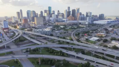
The Texas Department of Transportation (TxDOT) is currently planning a significant realignment of I-45, which runs downtown. The plan could remove an elevated portion of the highway known as Pierce Elevated.
Proposed Park Yet Another Hurdle for Houston Interstate Expansion
The Interstate 45 widening project, halted by a federal order and opposed by many local officials and organizations, could hit a new snag if White Oak Bayou becomes a city park.
A Freeway Rebellion Rises in the Unlikeliest of States: Texas
“There’s no train, there’s no bus, there’s no anything that supports mass transportation. It doesn’t exist.” -Houston resident Fabian Ramirez.

Planetizen Federal Action Tracker
A weekly monitor of how Trump’s orders and actions are impacting planners and planning in America.

Restaurant Patios Were a Pandemic Win — Why Were They so Hard to Keep?
Social distancing requirements and changes in travel patterns prompted cities to pilot new uses for street and sidewalk space. Then it got complicated.

Map: Where Senate Republicans Want to Sell Your Public Lands
For public land advocates, the Senate Republicans’ proposal to sell millions of acres of public land in the West is “the biggest fight of their careers.”

Maui's Vacation Rental Debate Turns Ugly
Verbal attacks, misinformation campaigns and fistfights plague a high-stakes debate to convert thousands of vacation rentals into long-term housing.

San Francisco Suspends Traffic Calming Amidst Record Deaths
Citing “a challenging fiscal landscape,” the city will cease the program on the heels of 42 traffic deaths, including 24 pedestrians.

California Homeless Arrests, Citations Spike After Ruling
An investigation reveals that anti-homeless actions increased up to 500% after Grants Pass v. Johnson — even in cities claiming no policy change.
Urban Design for Planners 1: Software Tools
This six-course series explores essential urban design concepts using open source software and equips planners with the tools they need to participate fully in the urban design process.
Planning for Universal Design
Learn the tools for implementing Universal Design in planning regulations.
Heyer Gruel & Associates PA
JM Goldson LLC
Custer County Colorado
City of Camden Redevelopment Agency
City of Astoria
Transportation Research & Education Center (TREC) at Portland State University
Camden Redevelopment Agency
City of Claremont
Municipality of Princeton (NJ)