


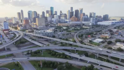
The Texas Department of Transportation (TxDOT) is currently planning a significant realignment of I-45, which runs downtown. The plan could remove an elevated portion of the highway known as Pierce Elevated.
Gail Delaughter reports on the planning effort in Houston that could lead to large overhaul of I-45 between Beltway 8 North and downtown Houston. According to Delaughter, "[th]e biggest changes are planned for downtown Houston, where TxDOT is considering tearing down the Pierce Elevated and realigning the freeway."
According to Delaughter, the current plan would split the segment into three sections—the project map included with the post shows realignments occurring on I-45, US 59, and Pierce Elevated. The plan also includes "managed lanes between the Beltway and I-10, along with new frontage road lanes and a bike trail."
TxDOT is expecting to complete the environmental study for the project in early 2016, after initially announcing the planning effort in November 2013. Currently, TxDOT is hosting a series of public workshops [pdf] about the plan, with the most recent meeting taking place on April 23, 2015. Public comments will be open until May 14, 2015. The article linked below includes an embedded version of the full plan.
FULL STORY: TXDOT Releases Plans On Major Redesign Of I-45 In Downtown Houston

Calling for the Removal of Houston's Pierce Elevated Freeway
Houston's Pierce Elevated, a section of the I-45 freeway, is the latest target in the movement to remove urban freeways.
A Freeway Rebellion Rises in the Unlikeliest of States: Texas
“There’s no train, there’s no bus, there’s no anything that supports mass transportation. It doesn’t exist.” -Houston resident Fabian Ramirez.
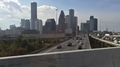
Contentious Houston Freeway Widening Project Inches Forward
Federal officials have given TxDOT the go-ahead to resume work on a small portion of a controversial interstate widening project in downtown Houston.

Planetizen Federal Action Tracker
A weekly monitor of how Trump’s orders and actions are impacting planners and planning in America.

Congressman Proposes Bill to Rename DC Metro “Trump Train”
The Make Autorail Great Again Act would withhold federal funding to the system until the Washington Metropolitan Area Transit Authority (WMATA), rebrands as the Washington Metropolitan Authority for Greater Access (WMAGA).

The Simple Legislative Tool Transforming Vacant Downtowns
In California, Michigan and Georgia, an easy win is bringing dollars — and delight — back to city centers.

The States Losing Rural Delivery Rooms at an Alarming Pace
In some states, as few as 9% of rural hospitals still deliver babies. As a result, rising pre-term births, no adequate pre-term care and harrowing close calls are a growing reality.

The Small South Asian Republic Going all in on EVs
Thanks to one simple policy change less than five years ago, 65% of new cars in this Himalayan country are now electric.

DC Backpedals on Bike Lane Protection, Swaps Barriers for Paint
Citing aesthetic concerns, the city is removing the concrete barriers and flexposts that once separated Arizona Avenue cyclists from motor vehicles.
Urban Design for Planners 1: Software Tools
This six-course series explores essential urban design concepts using open source software and equips planners with the tools they need to participate fully in the urban design process.
Planning for Universal Design
Learn the tools for implementing Universal Design in planning regulations.
Smith Gee Studio
City of Charlotte
City of Camden Redevelopment Agency
City of Astoria
Transportation Research & Education Center (TREC) at Portland State University
US High Speed Rail Association
City of Camden Redevelopment Agency
Municipality of Princeton (NJ)